|
THE CALEXICO BRANCH NILAND to CALEXICO, MP667.5 - MP708.5 Introduction Construction of the Calexico branch was
begun at the turn of the century.
This branch was the first of the tenuous web of rail lines that
even today still provide service to the Imperial Valley. In fact, the Calexico branch is currently
the only working US route into the valley from outside; this branch
connects the Sandia and El Centro branches at El Centro to the mainline
of the Espee. The branchline swings south, away from
the Yuma line, at MP667.4 in Niland.
From Niland, the tracks head nearly due south, passing through
the towns of Calipatria, Brawley and Imperial on the way to El Centro. From El Centro, the branch line continues
south to its terminus at the Mexican border in Calexico, at MP708.8. Although the tracks head south, the railroad
considers all traffic moving from Niland toward Calexico to be in the
East direction; conversely, all traffic moving from the U.S. Border
toward Niland is in the westbound direction.
Just remember that eastbound the mileposts count up, just like
on the mainline. 667.4 Begin CALEXICO Branch NILAND Crossovers EB Signal Tower WB Signal Bridge Begin Centralized
Traffic Control (CTC) Speed Limit: EB
20 MPH -120' AMSL; +0.3%
EB The Calexico Branch separates from the
Yuma Line at the Niland Crossovers, situated between the eastbound signal
tower at MP667.3 and the westbound signal bridge at MP667.4. Although it runs nearly due south, the
railroad direction from Niland toward Calexico is Eastbound; all traffic
running from Calexico toward Niland is considered to be Westbound. The Calexico Branch runs from Niland all
the way to Calexico, a distance of 41 miles, on fairly well-maintained
roadbed that sees year-round agricultural traffic.
A Southern Pacific Pipe Lines Company shares the right-of-way
supplying various petroleum products to the energy-intensive agriculture
of the Imperial Valley. 667.5 NILAND Station (CAL117C5) Nearly a hundred years ago the Southern
Pacific, excited by the prospects of the vast agricultural wealth of
the Imperial Valley, built the Calexico Branch. Originally called Old Beach, then Imperial
Junction, Niland gained its current name by 1920. Niland is not an incorporated town; it
is under the jurisdiction of the County of Imperial. In fact, along Main Street just about a
quarter-mile west of the MP667.8 crossing is the Imperial Country Sheriffs'
Station, next to the original jail that served Niland. It's worth a look. 667.6 East Switch 0594 Siding The 0594 siding provides access to and
from the 0593 and 0592 yard tracks that remain along the south side
of Niland Yard. The 0593
track branches off the 0594 lead at MP666.9; the west end of the 0592
track comes off the 0593 track at MP667.4. 667.9 Main Street Grade Crossing Calexico Switch
NILAND Wye EB/WB Interlocking
Signals End Centralized
Traffic Control (CTC) Begin Direct Traffic
Control (DTC) Begin CALIPATRIA
Block Signpost EB "END
CTC" Signpost WB "BEGIN
CTC" Signpost EB "BEGIN
CALIPATRIA BLOCK" Signpost WB "END
CALIPATRIA BLOCK" Signpost EB 25
MPH Speed Limit: EB
25 MPH; WB 20 MPH The branch has begun its curve to the south,
passing a few trailer parks to the south. The east leg of the wye joins the branch
track at the switch immediately south of the grade crossing. From the wye switch to yard limits in El
Centro at MP697.1, the railroad runs under Direct Traffic Control (DTC)
authority. Train crews wishing
passage over the two in-route blocks, Calipatria and Brawley, must verbally
request permission from the dispatcher before entry into either of the
blocks. 668.0 No Milepost Visible -125' AMSL; -0.1%
EB Access between Main Street and Noffsinger
Road is via the paved Commercial Avenue, west of the right-of-way, or
for the more adventurous via the dirt path that immediately fronts the
tracks on the west side. On the 1956 topo map of Niland, a west-facing
siding on the west side of the tracks connected to the branch near this
point. The siding was approximately
0.1 miles long. 668.2 Noffsinger Road Grade Crossing Agricultural "S"
Canal and Drain The grade crossing is protected with a
pair of lone crossbucks. Noffsinger
Road is the closest thing to paved access to the Espee Yuma Line at
MP671 and east. Further branch access to the south is available
along the east side of the tracks; this access path, however, dead-ends
about 0.6 miles south at a short bridge. The "S" Drain and the "S"
Lateral pass beneath the tracks, the Lateral carrying fresh irrigation
water to the croplands downstream to the west, while the "S"
Drain collects the runoff from upstream lands and channels this waste
water into the Salton Sea, approximately five miles west. As is the case here, when there are two
waterways flowing adjacent, generally the deeper, unlined one will be
the drain while the concrete-aproned one will carry fresh water for
irrigation. The whole Imperial Valley is plumbed with
a vast network of these rains and canals, designed to carefully manage
that most precious of commodities in this otherwise parched valley:
the water of the Colorado River. 668.7 Agricultural "R" Canal
and Drain The R Drain and the R Lateral pass beneath
the tracks, the Lateral carrying fresh irrigation water to the croplands
downstream to the west, while the R Drain collects the runoff from upstream
lands and channels this waste water into the Salton Sea, approximately
five miles west. 668.8 20' Wooden Bridge over Drainage Trackside access ends at the bridge.
Further four-wheeled vehicle travel will require a trip back
to Noffsinger Road, then a drive about 0.3 miles west to International
Road, which will then lead the intrepid journeyer south to Pound Road.
At Pound Road, head east 0.3 miles back to the railroad right-of-way. 668.9 Block Signal: WB D-6689 This signal is a distant indication for
westbound traffic approaching the Niland Yard at MP667.9. If this signal behaves anything like the
similar signals on the Riverside Branch at MP543.2 and MP544.2, this
signal can display either a yellow or a red aspect.
Assuming that this signal indeed works anymore. The October 1989 timetable states: "RULE 229. Calexico Branch: When Distant Signal 6689 displays Approach
aspect trains and engines must stop at signal and receive verbal instructions
from WR55 Train Dispatcher before proceeding to beginning of CTC at
Niland." 669.0 -160' AMSL; -0.6% EB 669.2 Pound Road Grade Crossing Agricultural "Q"
Drain and Canal Unpaved Pound Road is protected only by
crossbucks; 0.3 miles west is International Road, which provides northward
access to the tracks from Noffsinger Road at MP668.2. The eastside access path north along the
tracks is best; this path, however, ends about 0.4 miles north. To the south the only through access is
along the dirt path to the immediate west of the tracks. The path on the east side ends about 0.1
miles south. Approximately four miles west the "Q"
Drain flows through a carbon dioxide well field, which a hundred years
ago were sufficient to cause the name "Volcano Wells" to be
attached to the area. The
carbon dioxide leaking from far beneath the ground creates bubbling
mud pots on the surface. Neat
stuff. 670.0 -170' AMSL; -0.3% EB 670.2 McDonald Road Grade Crossing Agricultural "O"
Canal and Drain Crossbucks protect the crossing at paved
McDonald Road; the "O" Drain and "O" Lateral flow
on either side of the road. The access south lies along the west side
of the tracks; to the north through access is also along the west side
of the tracks. 670.7 Track Access from Shrimpf Road Agricultural "N"
Canal and Drain Shrimpf Road provides a dirt path access
from State Route 111, 0.5 miles west. The west side access path along the tracks
squeezes around a shrubbery. 671.0 -175' AMSL; +0.0% EB 671.2 Simpson Road Grade Crossing Agricultural "M"
Canal and Drain Twin High-voltage
Powerlines cross the Right-of-way A pair of crossbucks protect the intersection
of the railroad with the unpaved Simpson Road. Along the north and south sides of the
road run the water and electricity lines. Access to the north is along the west side
of the railroad; to the south there is fair access along both sides
of the tracks. 671.3 45' Wooden Bridge over Drainage 671.7 West Switch 0580 Siding Agricultural "L"
Canal and Drain 8' Wooden Bridge
over Drainage The 0580 siding lies along the east side
of the tracks; this siding serves the Estelle station at MP672.0. 672.0 ESTELLE Station -180' AMSL; -0.1%
EB Estelle station is first shown on a railroad
map of 1910. 672.2 Sinclair Road Grade Crossing Agricultural "K"
Canal and Drain Paved Sinclair Road marks its crossing
at the railroad tracks with a pair of crossbucks. Both north and south of the crossing there
are buildings; there is a private residence at the southwest side of
the intersection. 672.3 Old Estelle Station Building All that remains now is the abandoned,
decrepit, boarded-up station along the west side of the tracks at MP672.3. A single order mast stands out in front,
next to the tracks. Pigeons
live here now. The 1956 topo map of the area also shows
a 0.1 mile-long siding that sat across from the stationhouse, connecting
to the 0580 siding through an east-facing switch. 672.4 East Switch 0580 Siding 4' Wooden Bridge
over Drainage Access along the tracks from Sinclair Road
to Hoober Road is along the east side of the right-of-way. 672.7 Hoober Road Grade Crossing Agricultural "J"
Canal and Drain The dirt Hoober Road crosses the tracks
using a pair of the ubiquitous white crossbucks for protection. To the north, the east side access path
makes a narrow squeeze around the concrete abutment of the agricultural
drain. To the south, track
access is available continuing along the east side of the rails. 672.8 8' Wooden Bridge over Drainage 673.0 -180' AMSL; +0.0% EB The field to the east often has onions
growing. 673.2 Agricultural "I" Canal
and Drain The access continues both north and south
along the east side of the right-of-way, with just a minor tight squeeze
around the concrete abutment of the drain. The field to the southwest holds cattle
in pasture. 673.7 Agricultural "H" Canal
and Drain 673.8 EB/WB Block Signals (abandoned) The Calexico Branch, until about 1989,
was still under CTC operation from Niland to Calipatria. The entire branch still shows evidence
of more active days with these signals that remain in place, with the
faces pointed outward from the track to signify non-use, as according
to the rules. 674.0 -180' AMSL; +0.0% EB In the field to the east grows alfalfa;
huge towering boxcar-high stacks of it line the dirt access road along
the east side of the right-of-way many times a year. 674.2 Lindsay Road Grade Crossing Agricultural "G"
Canal and Drain Lindsay Road provides the first paved access
to the railroad from State Route 111 since Sinclair Road back at MP672.2.
The crossing is indicated by a pair of white crossbucks. The railside access path continues along
the east side of the right-of-way both north and south. The fields to the southeast have alfalfa
growing; to the southwest there is a cattle feedlot. 674.7 Trackside Buried Equipment Vaults Agricultural "F"
Canal and Drain There are two fiberglass equipment boxes
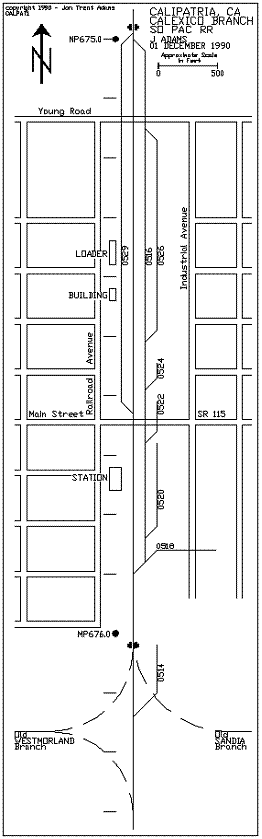
buried along the east side of the roadbed. 674.9 EB/WB Block Signals (abandoned) West Switch CALIPATRIA
(0529) Siding The Calipatria siding runs along the west
side of the tracks. 675.0 West Switch 0516 Siding -180' AMSL; +0.0%
EB Siding 0516 separates from the branchline
and parallels it along its east side, providing rail access to a couple
of spurs further ahead. The
east end of the 0516 siding is located at the other end of Calipatria,
about MP675.9. 675.1 Young Road Grade Crossing West Switch 0526 Siding
on 0518 Track Agricultural "E"
Canal and Drain Young Road provides paved access from either
State Route 111, about 0.2 miles west, or from either Industrial or
Railroad Avenues, situated on either side of the right of way. The dirt access road to the north along
the west side of the tracks has a "No Trespassing" sign posted. Access north is along the east side of
the railroad; the path is accessed by careful driving around the east
side of the burned-out and disheveled grain loader that still graces
the landscape immediately north of Young Road.
Flashing lights and bells indicate the crossing at Young Road. The 0526 siding branches off to the east
side of the 0516 siding. The 0526 track serves the loading lot along
Industrial Avenue on the east side of the right-of-way.
675.3 Grain Loader Serving CALIPATRIA
Siding 675.4 Trackside Building East Switch 0526
Siding A low blue and gray building sits immediately
west of the Calipatria (0529) siding; this structure serves as an office
for the loading service at Calipatria. The 0526 siding rejoins the 0516 siding
along the east side of the right-of-way.
At one time the trackage east of the main track was a bit more
complex; today there remains bits and pieces of it. Railroad Avenue is the paved road that
fronts the loading area on the west side of the right-of-way. It provides access from Young Rd. at MP675.1
down to Bowles Rd. around MP676. 675.5 East Switch CALIPATRIA (0529) Siding East-facing 0524
Spur (abandoned) The Calipatria (0529) siding ends about
15 feet north of the grade crossing. The 0524 spur at one time served a facility
located near the corner of Industrial Avenue and Main Street, but is
now nearly a memory. 675.6 Main Street (State Route 115) Grade
Crossing East-facing 0522
Spur off the 0516 Track Welcome to nearly downtown Calipatria.
The city center is about three or four blocks west, as is State
Route 111. Not much happens in this town nowadays,
save the occasional beet loadings and whatnot. The 0522 siding, connected off the 0516
track, crosses the road about 50 feet east of the main track; there
are stop signs on both sides of the intersection to control rail traffic,
requiring locomotives to come to a full stop before crossing Main Street. On the west side of the right-of-way Railroad
Avenue provides north and south access; to the east there is no worthwhile
access along the tracks, but Industrial Avenue does run north to Young
Rd. and south to about MP676.0. 675.7 CALIPATRIA Station There are remnants of wall and a full
slab floor to mark the location of the old building. Recently, enterprising residents had swept
clean the slab and installed a basketball hoop on a pole, making good
use of the smooth concrete floor. Calipatria has been a station on this line
since at least 1920, when it shows up on, of all things, a Santa Fe
Railway map of California. 675.8 East-facing 0520 Spur The 0520 spur branches off to the east
from the 0516 track. It
continues back toward the Main Street grade crossing, only to die out
where the rails were removed a few few feet from the 0522 switch at
MP 675.6. 675.9 East Switch 0516 Siding East-facing 0518
Spur The 0516 switch is the east end of the
0516 siding, which runs along the east side of the tracks from MP675.0. The 0518 spur serves a facility a few hundred
feet east of the railroad. 676.0 EB/WB Block Signals (abandoned)
(CAL117D5) Site of Old Water
Tank Westmorland Branch
Junction (abandoned) Sandia Branch Junction
(abandoned) Westmorland Wye
(abandoned) Agricultural "C"
Canal and Drain -175' AMSL; +0.1%
EB There is a great bit of history in this
neighborhood, most of which is now long gone. Here is the original junction to the still-in-service
Sandia Branch, and the junction to the long-abandoned and removed Westmorland
Branch. The Westmorland Branch peeled off from
the Calexico Branch just south (railroad east) of the 676.0 milepost. A west-facing switch led the branch off
the main line where it turned and ran west 6-1/2 miles, then turned
again and coursed due south another 6 miles to end in the town of Westmorland. The total branch length was about 13 miles
with the end of track at MP688.8.
The branch was first set in place during the 1920's, and was
finally removed in 1962. Its
route today is used by the agricultural drain. In 1956, stations on the Westmorland Branch
were: CALIPATRIA
675.7 VERDANT
679.1 Siding length 14 cars SHAMROCK
680.6 Siding length 7 cars FONDO
683.1 Siding length 21 cars WESTMORLAND
688.3 VERDANT was just east of the grade crossing
at Brandt Road, and just west of the crossing over the Alamo River. SHAMROCK station was just east of the intersection
of Hatfield and Bowles Roads. FONDO station was placed immediately after
the sweeping curve to the south, about 1/2 mile west of Gentry Road
and 1/2 mile south of Bowles Rd. The station at WESTMORLAND was immediately
north of State Route 86/78, and about 0.2 miles west of Forrester Road. The end of track was 0.5 miles south of
the crossing with the State highway. The Sandia Branch has so far not fully
suffered the same fate as the Westmorland Branch; a 16-mile piece of
it was abandoned and ripped up in the Seventies, and so the only access
to the remainder of the Sandia Branch is via El Centro and the old Holton
Inter-Urban Railway trackage. Originally,
the Sandia Branch separated from the Calexico Branch with a west-facing
switch just a hundred feet south of the Westmorland Branch switch and
ran due east approximately 5-1/2 miles; from there it turned and rolled
south nearly ten miles to the grade crossing at State Route 78, where
the end-of-track is today. The two searchlight signals are out of
service, turned away from the track as per the rules. The water tank footings along the west
side of the right-of-way are evidence of an earlier time when steam
still ruled the Imperial Valley. The Westmorland wye employed the turn from
the main to the Westmorland Branch and a mirror-image leg with an east-facing
switch on the Westmorland Branch and another east-facing switch on the
Calexico Branch. The access path along the west side of
the tracks is accessible from the south end of Railroad Avenue. To continue further south (east along the
railroad) the intrepid driver must follow the path west, paralleling
the C Lateral canal at MP676.1, then cross over the C Drain on the old
Westmorland Wye bridge and follow the dirt road as it curves back to
the Calexico Branch right-of-way. 676.1 East-facing 0514 Spur The 0514 spur separates from the branch
and parallels it along the east side of the tracks. The spur is several hundred yards long
and services the grain loaders east of the railroad. The access path that parallels the right-of-way
along the west side comes to an abrupt end at the C Lateral canal and
Drain. To continue south
(railroad east) the intrepid driver must follow the path west, paralleling
the canal, then cross over the drain using the old Westmorland Wye bridge
and follow the dirt road as it curves back to the Calexico Branch right-of-way. There is no good access along the east
side of the tracks all the way down to the Yocum Road grade crossing
at MP676.6. In fact, there are
private residences there and they will surely wonder what you're up
to. And there's also a pack of dogs. 676.4 East-facing 0511 Spur The 0511 spur lays on the east side of
the right-of-way and is a few hundred yards long, serving some loaders
on the property adjacent to the railroad. 676.6 Yocum Road Grade Crossing Agricultural "B"
Canal and Drain Paved Yocum Road is protected only with
a pair of white crossbucks. A
trackside access route leads north from Yocum along the west side of
the right-of-way,; to the south the access is best had along paved Kershaw
Road, about 150 feet east of the tracks. 677.0 No Milepost Visible -170' AMSL; +0.1%
EB 677.1 Albright Road Grade Crossing EB/WB Block Signals
(abandoned) Nectarine Lateral
Canal Vail Supply Canal Paved Albright Rd. employs a pair of gates
and the associated flashing lights to warn off motor vehicle traffic
at the grade crossing. The searchlight signals are turned away
from the right-of-way as per the rules. There is accress to both sides of the right-of-way
from Albright to Brownell Road. 677.6 Brownell Road Grade Crossing Nutmeg Lateral
Canal and Drain The grade crossing employs a pair of white
crossbucks for protection. 677.9 Bernice Siding/Station (abandoned) At one time there was a siding along the
west side of the right-of-way; this siding served the cattle loader
ramp, belonging to Superior Cattle Feeders, that still juts out into
the nothingness. The siding/station
name was Bernice, according to several Espee timetables. 678.0 -165' AMSL; +0.1% EB 678.1 Railroad Telephone Stand (abandoned) 678.2 Dowden Road Grade Crossing Nettle Lateral
Canal and Drain 10' Wooden Bridge
over drainage 678.3 Railroad curves to east The right-of-way bends a bit to the east
to go around Ramer Lake, a duck-hunting and fishing area along the Alamo
River just ahead. 678.6 Quay Road Private Grade Crossing Ramer Lake Access Quay Road is an unpaved, private road that
provides access to the lake facilities immediately west. Ramer Lake is part of the Finney-Ramer
unit of the Imperial State Wildlife Area. 678.9 EB/WB Block Signals (abandoned) Railroad curves
to west The two searchlight signals are out of
service, turned away from the track as per the rules. The railroad continues the curve around
Ramer Lake on the approach to the Alamo River crossing at MP679.8. 679.0 -165' AMSL; +0.0% EB Ramer Lake lies just to the west of the
right-of-way. 679.8 170' Wooden/Steel Bridge over the
Alamo River The railroad crosses over the Alamo River
using a steel plate-deck girder bridge 60' long. The approach testles to the bridge are
wooden and make the total length of the bridge about 170'. The Espee originally spanned the Alamo
River as early as 1903. 680.0 -160' AMSL; +0.1% EB The railroad straightens out and continues
now just west of due south. All
the way to Rockwood Station at MP681.0 there are shrubberies that hide
the right-of-way from the road. 680.5 Private Grade Crossing The road that crosses the tracks is dirt,
and serves as an access path for the Imperial Irrigation District to
the nearby canals. One a 1956 topo map there is a siding shown
along the east side of the tracks, extending south from this point all
the way to MP681.0, separate from the Rockwood siding just south. 681.0 ROCKWOOD Station No Milepost Visible West Switch ROCKWOOD
(0504) Siding Paved Road Separates
from Railroad -155' AMSL; +0.1%
EB The shrubberies that blocked the view of
the railroad from MP680.0 are now gone.
A dirt access path leads along the east side of the tracks to
the south, between the grain loader plant and the railroad. The main drag, Kershaw Road, continues
south, veering to the east around the plant. The 0504 switch indicates the west end
of the Rockwood siding, which lies along the east side of the tracks
serving the loader facility. The track access path crosses over the
siding track, then continues south alongthe east side of the tracks
to about MP681.2. 681.1 West Switch 0503 Siding The 0503 siding lays along the west side
of the tracks. 681.3 Track Access Road Grade Crossing The access road peters out to the south
along the east side of the tracks.
The path crosses the tracks and continues west to Jefferson Road,
about 0.4 miles away. Jefferson
Road provides the only reasonable wheeled access to Rutherford Road
and the rest of the railroad to the south. 681.4 East Switch ROCKWOOD Siding East Switch 0503
Siding EB/WB Block Signals
(abandoned) The two searchlight signals are out of
service, turned away from the track as per the rules. 681.5 Rutherford Road Grade Crossing There are gates, lights and bells at this
crossing. To the north,
there is no reasonable access immediately alongside the tracks; to the
south, there are heavy steel "NO TRESPASSING" signs that block
access along the dirt paths along both sides of the tracks. Kershaw Road ends at Rutherford Road just
east of the grade crossing. Kershaw
parallels the railroad north to Yocum Road at MP676.6. Continuing legal access to the south is
Best Road, about a quarter-mile east of the tracks. 681.6 Old Siding Track (abandoned) There are the remains of an old spur track
that separated from the railroad immediately south of the Rutherford
Road grade crossing, probably to serve the abandoned loader on the east
side of the tracks. An old
"DERAIL" sign still stands, along with a goodly stretch of
the siding track itself, but the switch that connected it to the mainline
is long gone. 682.0 -150' AMSL; +0.1% EB Between Rutherford Road and MP682 there
is no legal trackside access. Continuing
south, there is a fine pathway alongside the east side of the tracks,
ending at Chalupnik Road at MP682.5. 682.5 Chalupnik Road Grade Crossing One mile south of Rutherford Road on Best
Road lies the unmarked Chalupnik Road, immediately across the street
from 5210 Best Road. The right-of-way is about a quarter-mile
west of Best Road. The property
along the west side of the tracks is posted "NO TRESPASSING"
with more of those big steel-plate signs.
Maybe this means that THEY mean business. There is track access to the north along
the east side of the railroad; travel to the south (railroad east) along
the rails is impeded by irrigation ditches, shrubberies and the like. A pair of highway stop signs protect the
crossing. 683.0 Dickerman Road Grade Crossing -140' AMSL; +0.1%
EB Unpaved Dickerman Road joins Best Road
immediately across from the residence at 5110 Best Road. The grade crossing is marked with only
a single stop sign. Dickerman Road continues west to the entrance
gates to the City Of Brawley Sewage Treatment Plant, located down in
the New River gulley. Following
the dirt road that skirts the fence along the east side of the plant
leads the intrepid railfan to the northeast corner of the Del Rio Country
Club. Here, this road joins up with a dirt path
that heads east and crosses over the railroad at MP683.8. Access north along the rails is available
along the west side of the tracks; this path dies out about MP682.7,
though. Access south (railroad
east) is also along the west side of the rails; this too ends in about
a quarter-mile. 683.4 EB/WB Block Signals (abandoned) The two searchlight signals are out of
service, turned away from the track as per the rules. 683.5 Track Access from Ward Road Livesley Agricultural
Drain Best Road, a north-south paved road that
parallels the railroad about 1/2 mile east of the right-of-way, leads
the clever explorer to a dirt path just south of the canal. This is (more or less) Ward Road, which
heads west to the railroad about 1/3 mile away. The path is ill-defined but quite wide
for the majority of the distance. Once to the railroad the access road leads
south along the east side of the tracks. 683.8 Private Grade Crossing Del Rio Country
Club The track access road paralleling the tracks
crosses over to the west side of the right-of-way at a crossing marked
only with a beat stop sign. To
the west, the path skirts and enters the Del Rio Country Club property. If you're headed that way, watch out for
wild slices... The path
also joins up with the dirt road that winds down from the City Of Brawley
Sewage Treatment Plant and Dickerman Road back at MP683.0. Otherwise, continuing access to the south
is available from the dirt path that remains on the east side of the
railroad. This path will
eventually reach pavement at Shank Road at MP684.5. A rough, scratchy path leads about due
east from the grade crossing out to Best Road. Ahhh, the Del Rio Country Club.
A breath of civility, an exhaltation of the Scottish pastime
of Golf in the rabidly-hot lowlands of the Imperial Valley.
Several of the greens line up right along the railroad right-of-way,
so while watching for the seldom train one can also watch the duffers
duffing. The golf course remains to the west of
the railroad from MP683.6 to MP684.4. 683.9 Railroad Telephone Stand (abandoned) There are a few of these along the railroad.
What remains there are include a vertical pipe, some conduit
or wire, and sometimes a box. The eighth green of the Del Rio Country
Club golf course is just to the west. 684.0 -140' AMSL; +0.2% EB The hard-packed dirt access path lies along
the east side of the right-of-way; this path continues north to at least
MP683.4 and south to beyond Shank Road at MP684.5. 684.1 West-facing 0460 Spur The 0460 spur lies along the east side
of the right-of-way and extends about 0.4 miles south. 684.3 West-facing 0461 Spur The 0461 spur branches off to the west
of the railroad and provides service (of sorts) to the industries there. Green 6 is just west at the south end of
the golf course. 684.4 Grain Loaders Along Right-of-Way A host of worn grain loaders rest aside
the tracks, serving the 0460 spur and the main track. 684.5 Shank Road Grade Crossing EB/WB Block Signals
(abandoned) As before, the signals are turned away
from the railroad as per the rules. Employing the most modern in railroad protection
devices, there is a set of blinking lights and their associated gates
protecting the Shank Road crossing of the railroad. The access path that follows the railroad
lies along the east side of the tracks. To the north the path leads to at least
MP683.4. To the south the
path is no cake walk, but only if you have interest in getting all the
way down to Brawley along the tracks.
Otherwise, the easternmost path along the right-of-way will continue
to about MP685.6. 684.5 West Switch 0440 Siding West-facing 0455
Spur End CALIPATRIA
Block Begin BRAWLEY Block Signpost EB "Begin
Brawley Block; End Calipatria Block" Signpost WB "Begin
Calipatria Block; End Brawley Block" The 0440 track parallels the railroad along
the east side of the tracks to at least MP685.6, where it connects to
the 0430 siding through a trailing switch.
The 0430 track continues to MP686.0. The 0455 spur provides track access to
the Southwest Marketing Association packing and shipping facility along
the west side of the tracks. This
spur runs all the way down to MP685.0 where it joins to the 0451 spur. The signposts mark the end of the Direct
Traffic Control "Calipatria" block (to the north) and the
beginning of the "Brawley" block (to the south). Unless otherwise ordered by the dispatcher,
only one train at a time can be authorized occupancy authority within
these blocks. All orders
are passed by radio. 685.0 West-facing 0451 Spur -135' AMSL; +0.3%
EB The 0451 spur leads immediately west of
the right of way and connects at the 0455 switch to the 0455 spur paralleling
the main track. This spur
provides a runaround for locomotives switching cars at the loading facility
lying along the west side of the railroad.
The 0451 spur ends at approximately MP685.5 in a fitful mess
of rails and ties. 685.2 Brawley Municipal Airport The Brawley airport lies along the east
side of the tracks; the runway is aligned due east-west. 685.5 West-facing 0444 Spur Eastside Access
Path Ends The 0444 spur separates from the 0440 spur
and heads east into a industry, effectively preventing further four-wheeled
access to the south along the east side of the tracks. 685.6 West Switch 0430 Siding West-facing 0447
Spur West-facing 0445
Spur Track Access from
River Drive and Tenth Street The 0430 siding separates to the east from
the main track; the 0440 siding ends.
The 0430 siding will end at MP686.0. Access to the tracks to the south all the
way to Main Street at MP686.2 is available from River Drive or Tenth
Street, the intersection of which is immediately east of the railroad
right-of-way. The two industry spurs branch off from
the main track and serve some buildings located along SR111 to the west. 685.7 West-facing 0443 Spur The 0443 spur serves a building that fronts
on SR111, about 100 yards west.
The spur ends immediately before B Street. 685.9 B Street Grade Crossing B Street heads one block west to State
Route 111. Lights and gates
protect the crossing. 686.0 East Switch 0430 Siding West-facing 0432
Spur -115' AMSL; +0.2%
EB There is no "official" milepost
marker; but, the number 686 is spray-painted on a signal pole just east
of the 0432 switch. The 0430 siding rejoins the main track
at this point. The 0432
spur leads off east of the right-of-way from the 0430 siding, and ends
near Ninth and D Streets. 686.2 BRAWLEY Station Main Street (State
Route 78) Grade Crossing The Brawley station has been on the maps
since at least 1910. Access further
south is along the west side of the right-of-way all the way to beyond
Dogwood Road at MP687.5. This grade crossing is protected with gates,
lights and bells. 686.3 G Street Grade Crossing
West
End 0410 Spur The grade crossing employs gates, lights
and bells for protection. Access
along the railroad continues on the west side of the tracks. The 0410 spur separates from the main at
MP686.8, and services a few industries along the east side of the right-of-way.
There is an old loader just ahead that has a spotting sign "2"
alongside the spur. 686.5 East-facing 0416 Spur The 0416 spur services industries along
the east side of the tracks, and ends at MP686.4. 686.7 K Street Grade Crossing Signpost EB "STOP"
for west spur track East-facing 0412
Spur The grade crossing employs gates, lights
and bells for protection. Access
along the railroad continues on the west side of the tracks. 686.8 Malan Street Grade Crossing
East-facing 0410 Spur The 0410 spur separates from the main and
heads north along the east side of the tracks to end just before G Street. The grade crossing employs gates, lights
and bells for protection. 686.9 EB/WB Block Signals (abandoned) The two searchlight signals are out of
service, turned away from the track as per the rules. 687.0 -110' AMSL; -0.1% EB The westside access path veers away from
the tracks and forages through some growths of shrubberies. 687.4 Best Canal and Drain No, this is not a judgement call. "Best" is the name of the canal,
like the name of the north-south road one mile east. The access path narrows to pass this point;
just ahead the path passes over the remains of a spur track that joined
the main with an east-facing switch and went as far north as B Street
in Brawley, if you can believe the USGS. 687.5 Dogwood Road Grade Crossing Access to the west side of the tracks is
available both north and south from Dogwood Road. The crossing uses gates, lights and bells
for traffic control. The dirt road heading south along the west
side of the tracks provides ready access to a farmhouse-run local sausage
factory, said by locals to be the very best in the land. 687.9 Mead Road Grade Crossing Rockwood Canal
and Drain The Imperial Irrigation District's Rockwood
Power Substation rests immediately southeast of the dirt grade crossing.
There is access both north and south along the west side of the
tracks. A single crossbuck marks the crossing. 688.0 -115' AMSL; +0.0% EB 688.4 EB/WB Block Signals (abandoned) DeMoulin Road Grade
Crossing The two searchlight signals are out of
service, turned away from the track as per the rules. A single stop sign marks the unpaved grade
crossing. 688.9 Schartz Road Grade Crossing Unpaved Schartz Road employs twin crossbucks
to mark the crossing. Dogwood
Road is 0.3 miles east. Access
to the north along the railroad is available along the west side of
the tracks. To the south,
however, Lavender Canal blocks passage. 689.0 -115' AMSL; -0.1% EB 689.4 Grade Crossing This unnamed dirt road provides access
to both sides of the tracks from Dogwood Road. A pair of stop signs guard the crossing. 689.8 6' Wooden Bridge over drainage 689.9 Carey Road Grade Crossing The paved crossing is equipped with a pair
of crossbucks. An abandoned spur, no longer connected
to the railroad, is still visible in the pavement of Carey Road, curving
west to the loader facility south of Carey. 690.0 EB/WB Block Signals (abandoned) West-facing 0362
Spur -120' AMSL; +0.0%
EB The two searchlight signals are out of
service, turned away from the track as per the rules. The 0362 track serves the loader facility
along the east side of the railroad. Note that there is a derail track on the
spur that prevents (at least, in theory) unattended frieght cars from
rolling downhill on the spur and fouling the main. 690.3 GRAPE Station There is no siding now. There is a long, flat area next to the
east side of the main that looks like it was the subroadbed to a siding
at one time in the recent past. 690.8 4' Wooden Bridge over ditch EB/WB Block Signals
(abandoned) The two searchlight signals are out of
service, turned away from the track as per the rules. 691.0 Keystone Road Grade Crossing (County
Route S27) -115' AMSL; +0.5%
EB Although the paved Keystone crossing is
immediately before the 691 milepost, the crossing signal case is marked
with "691.0". The crossing uses lights, gates and bells
to warn motorists and cattle. Access to the north is available along
the west side of the tracks; to the south, however, access is possible
only along the east side of the railroad all the way to Harris Road. Go immediately east of the big ditch and
then turn south to follow the tracks. For the next half-mile, a waste water disposal
area lies along the west side of the right-of-way; further west is the
Holly Sugar mill. 691.4 CARLTON Station East-facing 0355
Spur Carlton station contains the 0355 siding
that provides service to the Holly Sugar Refinery located at the southeast
corner of State Route 86 and Keystone Road, about one mile west. 691.5 35' Wooden Bridge over drainage 691.9 EB/WB Block Signals (abandoned) The two searchlight signals are out of
service, turned away from the track as per the rules. The searchlight head of the signal on the
east side of the tracks (the "west"-bound signal) has vanished,
whether by theft or as a replacement for an ailing signal somewhere
else. 692.0 Dahlia Canal -90' AMSL; +0.2%
EB 692.6 Dahlia Lateral #8 Canal The access paths on either side of the
tracks squeeze a bit to get over the canal. About 0.2 miles south the eastside access
path passes over a wooden bridge; the westside access path dies out. 693.0 Harris Road Grade Crossing -75' AMSL; +0.2%
EB The paved crossing is marked with gates,
lights and bells. Access north or south along the tracks
is available along the east side of the tracks. Shrubberies grow along the tracks to at
least MP693.3. 693.4 EB/WB Block Signals (abandoned) The westside signal head is gone; in its
place is a small solar panel. The
eastside signal is turned away from the tracks, as per the rules. 693.7 Larsen Road Grade Crossing West-facing 0344
Spur The 0344 spur begins immediately south
of the grade crossing and services the agricultural chemical company
located along the east side of the railroad.
The spur is about 300 yards long. There is access along the west side of
the tracks to the south; the path is right on the ballast, though, and
so may not be a wise idea. With
all that tamarisk and the curve in the tracks just ahead, just think
about the possibility of meeting a westbound SD40 at 25 mph. Also, driving on the ballast puts a lot
of wear and tear on the roadbed. 693.9 West-facing 0341 Spur The 0341 spur separates from the main and
serves a cotton cooperative along the west side of the tracks. The access path crosses over the spur at
a crude, unmarked grade crossing. 694.0 -65' AMSL; +0.0% EB 694.1 Ralph Road Grade Crossing A huge water tank belonging to a cotton
growers cooperative rests upon a 150' tower about 200 yards west of
the paved grade crossing. Access south along the railroad is available
along either side of the tracks. 694.6 Neckel Road Grade Crossing The unpaved grade crossing has a single
crossbuck to mark the intersection.
To the southwest is a new housing development. Access further south is best along the
west side of the tracks. 694.7 EB/WB Block Signals (abandoned) The eastbound signal is turned away from
the railroad as per the rules.
The signal head and mast are missing from the other signal. 695.0 No Milepost Visible West Switch 0322
Siding East-facing 0336
Spur West Switch 0333
Siding -65' AMSL; +0.0%
EB The 0322 siding is on the east side of
the tracks; the 0336 spur branches off the 0322 track. The 0333 siding runs along the west side
of the tracks. 695.1 14th Street Grade Crossing The grade crossing has a pair of crossbucks
for protection. A concrete
loading ramp sits next to the 0333 siding on the west side of the tracks
just south of the crossing. To
the east, near the intersection of 14th and N streets, there are the
remains of a spur that once connected to the 0322 siding immediately
south of the 0336 switch. 695.5 East Switch 0333 Siding West Switch 0331
Siding West-facing 0334
Spur on 0322 Track The 0333 siding lies along the west side
of the mainline; the 0331 switch is immediately south of the 0333 switch. The 0334 spur branches off the 0322 track
to service industries east of the right-of-way. 695.6 IMPERIAL Station Barioni Boulevard
(County Route S28) Grade Crossing The grade crossing at Barioni Boulevard,
also called Main Street by the locals, employs gates, lights and bells
for protection. There is no through access to the south
from Barioni to 2nd Street at MP696.0.
Along the west side there is only foot access, and on the east
the path ends about 4th Street.
Best route is to go east to N Street, then south to 2nd Street,
then cross the tracks and head north.
Or, you can walk. It won't kill you. (Maybe.) 695.8 East-facing 0328 Spur on 0322 Track East Switch 0331
Siding The 0328 track separates from the 0322
track and follows the east side of the main to end just before Barioni
Blvd. The 0331 siding lies
on the east side of the main and ends 1500' north at MP695.5. 695.9 East-facing 0326 Spur East Switch 0322
Siding EB/WB Block Signals (abandoned) The 0326 spur comes off the 0322 track
and travels north and east along the right-of-way to end about 100 yards
south of Barioni Blvd. The two searchlight signals are out of
service and are turned away from the railroad as per the rules. 696.0 No Milepost Visible 2nd Street Grade
Crossing Electric Car Puller
on Spur Track -65' AMSL; +0.1%
EB The grade crossing employs two crossbucks
to mark the intersection. The
very crudely marked "696.0" can be seen on the crossbuck on
the east side of the intersection. An interesting and unusual device: an electric
car-spotting winch is positioned next to the 0316 spur that serves the
business on the east side of the tracks a few hundred feet south of
2nd Street. The 0316 spur also blocks trackside access
along the east side. Access
south is available to MP696.5. 696.1 East-facing 0316 Spur East-facing 0315
Spur The 0316 track serves a loader along the
east side of the tracks just south of 2nd Street. The 0315 spur, like the 0316, heads north
to end just before the 2nd Street grade crossing. To continue further south along the west
side of the tracks, the access path crosses over the 0315 spur on a
crude grade crossing. 696.5 West-facing 0313 Spur Imperial County
Fairgrounds The 0313 track separates from the main
and curves due west to bring a very important commodity to the Imperial
Valley: beer to the beer distributor located adjacent to SR86 a quarter-mile
west. The one bad thing about this is that, in
doing so, the spur blocks further vehicular passage south along the
west side of the tracks.
In other words, to continue south, turn around and go back to
2nd Street, then go east to Clark Road, then south to the dirt canal
road that leads in from Clark Road, about a quarter-mile east of the
tracks. This road will lead
back to the tracks, this time along the east side. However, passage south to Aten Road may
not be possible except for sure-footed vehicles. Be careful. 697.0 No Milepost Visible -60' AMSL; +0.1%
EB The railroad has begun a gentle curve totalling
about 15 degrees to the east. This
is the final bend in the tracks before its straight shot to Calexico
and the Mexican Border, nearly twelve miles distant. The access path along the east side of
the tracks wallows along the perimeter fence of the chemical facility
adjacent to the east side of the railroad; an old siding, abandonded
long ago and no longer connected to the main, blocks further travel
south to all but the most insane. 697.1 Aten Road Grade Crossing Santa Fe Pacific
Pipe Lines Facility End Direct Traffic
Control (DTC) End BRAWLEY Block Begin EL CENTRO
Yard Limits Signpost EB "END
BRAWLEY BLOCK" Signpost WB "BEGIN
BRAWLEY BLOCK" Signpost EB Y
(Yard Limits) The railroad leaves the Direct Traffic
Control (DTC) limits and enters the El Centro yard limits, which extend
all the way to MP702.0. At the southwest corner of the intersection
is the big Santa Fe Pacific Pipe Lines facility, supplying plenty of
petroleum products to the Imperial Valley. To the south, to Clark Road at MP697.6,
the only trackside access is along the west side of the railroad. Aten Road is a big production. Four lanes wide, gates, lights, bells and
whatnot. 697.4 East-facing 0310 Spur The 0310 track separates from the railroad
and heads into the tank car facility that lies along the east side of
the tracks. The spur is
about 200 yards long. 697.5 Signpost WB 25 MPH 697.6 Clark Road Grade Crossing The intersection of the tracks and paved
Clark Road is marked with lights and bells. The crossing light assembly on the north
side of the intersection has a small solar panel mounted atop the mast. Access to the south along the tracks is
possible by travelling north of the grade crossing about 100 feet, crossing
the little bridge over the Date Canal on the east side of Clark Road,
then heading south a hundred yards to the crossing over the Central
Drain. 697.7 WB Block Signal (abandoned) West Switch 0102/0202
Siding West Switch 0103/0203
Siding on 0102/0202 Track Unpaved Grade Crossing Signpost WB "BLOCK
SYSTEM LIMIT" Central Drain /
Date Canal This is the west end of the El Centro yard.
The 0102/0202 and 0103/0203 tracks lie along the west side of
the main to about MP699.1. In fact, the 0103/0203 track provides access
to the El Centro Branch. The
siding tracks have two designators; the first number indicates the name
on the switch target at this end of the yard, while the second number
is what's written on the corresponding switch target at the other end. The westbound signal, which used to control
this end of the yard, has long since lost its signal head. The meaning behind the westbound signpost
is not quite apparent; actual limit of the block system is indicated
by the suite of signs south of the Aten Road grade crossing at MP697.1. Maybe this is an early warning. The unpaved grade crossing allows access
south along the Date Canal which flows under the railroad toward the
north. Access along the railroad is available
on a fairly good dirt road that begins at the Central Canal crossing
and then parallels the tracks on the east side all the way to El Centro. The passage is a bit narrow in some places,
but there's little rail traffic, and the careful railfan will keep his
(or her) eyes open, anyway. 698.0 -50' AMSL; +0.1% EB West Switch 0105/0305
Siding West Switch 0106
Siding The 0105 target marks the west end of a
siding that runs all the way down to MP699.7, where as the 0305 siding
it rejoins the main line. 698.7 West Leg EL CENTRO Branch Junction The 0103/0203 track, lying along the west
side of the right-of-way, provides access to the El Centro Branch wye.
The El Centro wye track also effectively ends westside motorized
access from the north.
698.9 EL CENTRO Branch Alignment Stretches
to West The wye tracks that lead off from the Calexico
Branch join about 200 yards due west and continue west as the El Centro
Branch. The railroad, however,
considers this stretch of track to be headed eastward, toward the setting
sun. This is the route to San Diego; originally
built in the 1910's as the western extension of the Holton Inter-Urban
Railway, the branch line heads west over Imperial Valley's bleak west
mesa to the end of the branch just beyond Plaster City, about 18 miles
west. At Plaster City the
line connects to the eastern end of the present San Diego and Imperial
Valley Railroad, which during the last decade or so has actually had
unbroken rail access all the way to the streets of San Diego. The mileposts along this line begin at
San Diego and count upwards toward the desert; that's why the final
milepost on the El Centro branch at the junction with the Calexico Branch
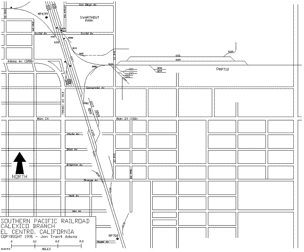
is 147.8. 699.0 West Leg SANDIA Branch Junction East Switch 0106/0206
Siding -45' AMSL; +0.2%
EB The west-facing 0912 switch connects the
west leg of the Sandia branch wye to the 0105/0305 siding along the
east side of the railroad. The east switch of the 0106/0206 siding
lies immediately before the branch junction along with a single crossover
that allows passage from the mainline onto the Sandia Branch. The Sandia Branch is better known to old
timers as the Holton Inter-Urban Railway, built in the Teens but bought
up by the Espee in the Thirties. 699.1 Euclid Avenue Grade Crossing East Leg EL CENTRO
Branch Junction Cross Road intersects with Euclid just
east of the right-of-way. From
this point north motor vehicle access is best along the east side of
the tracks all the way back to Clark Road at MP697.6. Access further south along the tracks leads
right through the Espee's El Centro Station, along the west side of
the tracks, and through the Sandia Branch wye on the east side of the
tracks. 699.2 SANDIA Branch Alignment Stretches
to East Looking east from this point you can see
the Sandia Branch tracks heading into the distance along the north side
of the El Centro industrial area. One the west side of the tracks the 0621
track leads into the Diesel pen lying at the northeast corner of Commercial
Avenue and Fourth Street. There
are usually several engines loitering on the pen tracks. 699.3 Commercial Avenue Grade Crossing Commercial Avenue provides access west
to Fourth Street and east to Third Street. 699.4 EL CENTRO Station East Leg SANDIA
Branch Junction Southern Pacific
El Centro Communications Facility The current SP El Centro Station is the
bleak, tan, plaster structure along the west side of the right-of-way. A much-older depot lies along the east
side of the tracks just north of the Main Street crossing. An Espee microwave communications tower
lies just south of the building.
This microwave facility relays signals from Superstition Mountain,
west of Brawley, to Midway, near Interstate 8 about 30 miles east. Local VHF radio operations support the
161.550MHz road channel. 699.5 Main Street (County Route S80) Grade
Crossing An old Espee depot lies immediately north
of the Main Street grade crossing along the east side of the main line.
The 0212 spur 699.6 West Switch 301 Siding 699.7 East Switch 301 Siding 699.8 Orange Avenue Grade Crossing 700.0 -40' AMSL; +0.1% EB 700.3 Ross Road Grade Crossing 700.8 Interstate 8 Overpass 701.0 -35' AMSL; +0.2% EB Desert Trails Campground to west 701.4 Danenberg Road Grade Crossing 701.5 JEWETT Station 702.0 End Yard Limits Begin Absolute
Block Register Territory (ABR) -25' AMSL; +0.1%
EB 702.5 McCabe / Dogwood Road Grade Crossing 703.0 -20' AMSL; +0.1% EB 703.6 Corell Road Grade Crossing 704.0 HEBER Station -15' AMSL; +0.2%
EB 704.1 Heber Road (State Route 86) Grade
Crossing 704.6 Fawcett Road Grade Crossing 705.0 -5' AMSL; +0.1% EB 705.5 Jasper Road? Grade Crossing Central Main Canal
Crossing 706.0 +0' AMSL; +0.0% EB 706.6 Cole Road Grade Crossing 707.0 +0' AMSL; +0.1% EB 707.1 Bridge over All-American Canal 707.6 Birch Street (State Route 98) Grade
Crossing 707.8 Sheridan Street Grade Crossing McKinley Street
Grade Crossing 707.9 Lincoln Street Grade Crossing 708.0 Grant Street Grade Crossing +0' AMSL; -0.1%
EB 708.5 CALEXICO Station Second Street Grade
Crossing 708.6 Imperial Avenue (State Route 111)
Grade Crossing (Southbound
Lanes Only) 708.8 End CALEXICO Branch United States /
Mexico International Border |