|
Winter
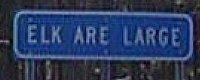
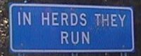
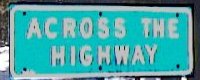
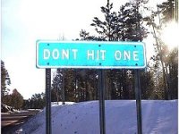
Wonderland Road Trip Getting out of town, for me, is sometimes a challenge in itself. I had sworn to myself that I would leave early Sunday morning, maybe as early as 4am. Since the drive time to Santa Fe is about 14 hours, I'd get there before sunset and in so doing pass through the highest points of the route (the Arizona Divide, just west of Flagstaff; the Continental Divide, just east of Gallup, NM) during the warmest part of the day. This would tend to remove the concern about black ice and snow from the drive. As it was, however, I woke up to the warming sun, read the paper, puttered about, cleaned the living room, played with the cat, etc. And I knew that the truck was due for its oil change and the tires needed to be rotated. Underlying all this was a general lethargy on going anywhere, and instead staying home and spending time vegetating there. The truck was packed, so once that was completed, I could continue east into Arizona. altadena, los angeles county, california 54505 @ 245pm -- pasadena -- interstate 210 (foothill freeway); michillinda avenue (named after the three primary colonies that settled the san gabriel valley over 100 years ago; michigan-illinois-indiana -- arcadia the san gabriel mountains stand out in sharp relief -- monrovia mount san gorgonio (the highest peak in southern california at 11,503'), mount san jacinto (10,834') and mount san antonio, aka mount baldy (10,094'), each the highest peak in its respective mountain range, are all visible on this clear winter's day -- duarte -- irwindale the stench of the miller brewery is tremendous; i wonder how people can live downwind of it? of course, the brewery has been here longer than the more recent neighborhoods but there must be a lot of resentment; on a lite note, the miller beer sign at the brewery is rumored to be the world's largest rotating sign, and it's a big one -- azusa there are at least two theories on the origin of the name "azusa": the first is that it's a derivation of a local indian word; the second is that it means "everything from a to z in the usa", which smacks of definite boosterism, especially since there's little here but the entrance to the huge san gabriel canyon -- glendora got the tires rotated (ya know, the tires only work if they rotate, so i'm not sure why i had to do this) -- san dimas the traffic, while light, was concentrated enough that I could do no better than 65-70 mph -- san jose hills (raging waters and bonelli regional park)-- pomona home to the los angeles fair and the world's largest computer shows held on a monthly basis -- interstate 10 (san bernardino freeway) -- claremont -- san bernardino county -- montclair about 12 miles due north at mountain avenue is mt san antonio peak -- ontario -- upland approaching the interstate 10 / 15 interchange, i reconsidered my route selection - i had planned to take interstate 15 to barstow, thence interstate 40 east about 600 miles to interstate 25 at albuquerque - from there it was an easy 72 miles up interstate 25 to my mom's; but, it was 4pm, the weather forecast promised a cold night at the higher elevations in arizona, and flagstaff was 7000' up; i wouldn't get there until around midnight, and if i were to want to stop and sleep it would be a very cold night, with reported temps around 0°f; even sleeping in the truck i'd freeze - in fact, that route would place me at an elevation of more than a mile soon after crossing into arizona, and that'd be only about 4 hours away -- guasti i quickly reviewed the potential routings, and selected the interstate 10 to phoenix route; from there i could take arizona state route 87 (the beeline hwy) from mesa northeast to payson, then continue north and east up over the mogollon rim and into the painted desert; it'd be at least 6 hours before i'd get above a mile elevation so i could go farther and still stay warmer tonight -- fontana -- bloomington -- rialto -- colton -- san bernardino the interstate 10 / interstate 215 freeway interchange is huge, with high bridges that arc across the sky; the interchange is built upon the trace of the san jacinto earthquake fault; in robert sharp's text of geology: field guide to southern california (1976) he states "i never pass over, under or through this freeway interchange without imploring the earthquake gods to hold everything for a few seconds until i am clear of the maze of structures" -- loma linda -- redlands -- yucaipa local sunset at about 4:40pm -- calimesa -- riverside county -- beaumont the top of the san gorgonio pass at about 2600' -- banning -- cabazon about 3 miles east of the big lizards i cross the 21-mile-long line that connects the two highest peaks in southern california, san gorgonio on the north and san jacinto to the south; the two peaks tower some 9,000' to 10,000' above me, providing a local topographic relief no less formidable than the sierra or the rockies and exceeded only by denali, at least in north america -- whitewater san gorgonio pass is also called whitewater pass -- whitewater river (dry): issues forth from whitewater canyon, which drains the southeast face of san gorgonio mountain; a desert river, there is rarely any surface water -- coachella valley -- garnet the local hills and desert floor are covered with wind-powered electricity generators, a vast sea of whirlagigs that make only a faint humming noise as they rotate in the usually fierce wind that channels through this pass -- palm springs -- thousand palms i've never verified this -- bermuda dunes -- indio the date capital of the world, and low point of the trip at about 10' below sea level; to the southeast, the salton sink reaches an elevation of about 230' below sea level, exceeded in north america only by badwater (-278') at death valley -- cactus city really just a caltrans highway rest stop but some maintenance folks live out here -- shavers valley -- chiriaco summit home to the general george patton museum; the desert out here and to the northeast was used by patton during the early years of world war two as a training ground for learning desert warfare against the nazis -- chuckwalla valley -- desert center immortalized in the suburban lawn's classic "flying saucer safari" -- hell never saw anything but it's on the map -- palo verde mesa -- nicholls warm springs -- palo verde valley -- blythe the scent of chemical-powered agriculture, pesitcides, herbicides, fungicides and somewhere in there the smell of good earth and water -- colorado river, a mere shadow of its former self -- arizona -- la paz county -- saguaro cacti ehrenberg -- dome rock mountains -- la posa plain -- quartzsite snowbird heaven; old chainsmoking geezers, rockhounds and junk traders maintain tables piled high with artifacts of previous and alternate civilizations, all for sale at reasonable prices -- plomosa mountains -- ranegras plain -- maricopa county -- harquahala plains -- tonopah desert tonopah not the tonopah from the country song -- hassayampa river (dry) -- buckeye nary a ohioan to be seen; wonder if that's where the name originated? -- buckeye valley -- white tanks mountains -- goodyear -- agua fria river (dry) -- salt river valley -- tolleson -- phoenix -- sr202 -- scottsdale -- salt river (mostly dry) -- tempe -- mesa@2210 - got fuel 54899, 31.4 gal, 1.139/gal, 87 octane at am-pm -- sr87 (country club rd, beeline hwy) -- salt river indian reservation -- fort mcdowell indian reservation -- tonto national forest -- camped out on beeline hwy 3 miles before the bush hwy, on the verge of the adams mesa. up at 0715 mst: in the midst of a saguaro forest -- beeline in nice shape, very scenic, much improved from the last time i drove it in 1992? -- four peaks northeast side with snow -- round valley -- mazatzal mountains -- gila county -- sunflower the highway is two-lane, runs through the middle of a narrow riverbottom -- beeline torn up a bit for a few miles before gila/maricopa county line -- rye snow on roadside -- payson stop and get a refill on my double big gulp of diet coke and a shot of dr pepper -- sr 260 -- star valley -- tonto basin -- kohls ranch -- christopher creek -- impressive roadwork on verge of mogollon rim with multiple bridges over dropoffs on south side of rim -- mogollon rim -- sitgreaves national forest -- coconino county -- arizona department of highways "burma shave"-style sign as follows:
-- 7700' summit -- mogollon mesa -- forest lakes
-- navajo county -- start of good mormon towns -- heber
-- overgaard -- clay springs -- pinedale
-- linden -- showlow the story is
that the townsite ownership traded hands as the result of a lost poker
hand, hence the name -- us60 -- apache county -- sr61 -- concho
-- us180/sr61 -- saint johns -- us191/sr61 -- little
colorado river -- us191 used to be us666 the devils' highway, but i
think that there must have been complaints about the number, so the
dot went and changed most of it; a little further south, the us666 number
had applied for decades to the coronado trail, a sinous, high-altitude
traverse of the high country of the sitgreaves national forest; the
difficulty of that drive certainly made it the devil's highway in my
book -- zuni river -- witch well -- sr61 -- zuni indian
reservation -- new mexico @ 11:30am mst -- mckinley county -- pavement
improves (rare for nm) -- sr53 -- zuni - kids and mongrel
dogs, junk cars -- black rock -- cross rio pescado
-- pescado -- ramah -- lunch at the
stagecoach inn: regular burrito and cup of green chile about $7 w/tax;
pleasant people, good food -- cibola county -- ramah navajo indian reservation
-- sunset village -- el morro national monument --
cibola national forest -- tinaja -- zuni mountains
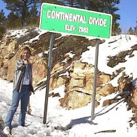
-- continental divide several days pass; eat at maria's new mexican kitchen, the best new mexican food and margaritas in the world (555 w cordova rd, 505-983-7929), drink at wolf canyon (505-438-7000), eat and drink at catamount bar and grill (125 e water st, 505-988-7222), drink at cowgirl hall of fame (319 s guadalupe 505-982-2565). celebrate new year's with the family. leave mom's at 813am pst -- santa fe -- us285 -- i25
-- us285 (saint francis drive) -- got fuel 55663, 22.0 gal, 1.299/gal,
87 octane at allsups -- sr14 (cerrillos road) -- i25 -- sandoval county
-- santo domingo indian reservation -- san felipe indian reservation
-- algodones -- bernalillo -- sr44
(vasquez de coronado's route) -- rio grande -- santa ana indian reservation
-- zia indian reservation -- zia pueblo -- big chief
35°29.7N / 106° 45.7W up at 0630 -- inside truck temp is 38°f, according to nws, dropped
to at least 31°f outside; however 1/4" thick ice in puddles
on unpaved road; the amtrak southwest chief rolls by around 6:45 --
flagstaff, go to most excellent macy's european coffee
house and bakery and get triple cappucino, blueberry-cinnamon twist
and raspberry cream cheese roll -- sr89a |
 35°00.6N / 108°07.1W elevation 7882' -- el malpais national
monument -- san rafael -- red metal roofs on homes
and other structures - bright red, maybe it ages to brick red? huge
building on left three stories, with blue roof -- grants
-- sr122: uranium café, lavaland motel -- make error and accidentally
get on i40 eastbound -- get off i40 next exit, rejoin sr124 -- acoma
indian reservation -- mccartys -- san fidel
-- villa de cubero -- cubero -- budville
one structure, seems to be a store?, mission here -- laguna indian reservation
-- paraje -- new laguna -- laguna
pueblo -- miss turn, get onto i40 eastbound by accident --
get off i40 exit 117 -- mesita -- backtrack on old
66 (sr124?) north side of interstate -- back at laguna pueblo,
turn around again and head back on old 66 -- mesita
-- cross to south side of i40, pass a herd of cattle roaming across
road; road becomes covered with snow, some tracks, no vehicles met
35°00.6N / 108°07.1W elevation 7882' -- el malpais national
monument -- san rafael -- red metal roofs on homes
and other structures - bright red, maybe it ages to brick red? huge
building on left three stories, with blue roof -- grants
-- sr122: uranium café, lavaland motel -- make error and accidentally
get on i40 eastbound -- get off i40 next exit, rejoin sr124 -- acoma
indian reservation -- mccartys -- san fidel
-- villa de cubero -- cubero -- budville
one structure, seems to be a store?, mission here -- laguna indian reservation
-- paraje -- new laguna -- laguna
pueblo -- miss turn, get onto i40 eastbound by accident --
get off i40 exit 117 -- mesita -- backtrack on old
66 (sr124?) north side of interstate -- back at laguna pueblo,
turn around again and head back on old 66 -- mesita
-- cross to south side of i40, pass a herd of cattle roaming across
road; road becomes covered with snow, some tracks, no vehicles met  34°53.2N / 107°03.8W -- dalies -- los
lunas -- get on i25 to take picture of a water tank with tiger
paintjob
34°53.2N / 107°03.8W -- dalies -- los
lunas -- get on i25 to take picture of a water tank with tiger
paintjob 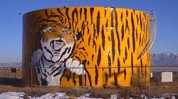 34°49.2N / 106°44.5W -- isleta indian reservation -- bernalillo
county -- isleta -- rio grande -- albuquerque
off at central/lead/coal -- old 66 (central) -- got fuel at circle k
55378, 32.3 gal, 1.119/gal, 88 octane -- nm333 -- tijeras canyon --
cibola national forest -- tijeras -- sedillo
-- santa fe county -- edgewood -- sr344 -- local road
-- stanley -- sr41 -- local sunset -- galisteo
-- us285 -- lamy -- santa fe -- arrive
at mom's around 5:15pm mst
34°49.2N / 106°44.5W -- isleta indian reservation -- bernalillo
county -- isleta -- rio grande -- albuquerque
off at central/lead/coal -- old 66 (central) -- got fuel at circle k
55378, 32.3 gal, 1.119/gal, 88 octane -- nm333 -- tijeras canyon --
cibola national forest -- tijeras -- sedillo
-- santa fe county -- edgewood -- sr344 -- local road
-- stanley -- sr41 -- local sunset -- galisteo
-- us285 -- lamy -- santa fe -- arrive
at mom's around 5:15pm mst 35°32.3N / 105°54.5W.
 --
san ysidro -- climb up the eastern scarp of the colorado
plateau; cabezon peak prominent to southwest -- zia indian reservation
-- cuba stop at circle k and refill double gulp, get
some fig newtons; silly mongrel dog makes his nest next to the gas pumps
-- west on sr197 (navajo 9) -- flying horse ranch: so that's where mobil's
pegasus went! -- clara's trading post -- torreon wash
-- torreon three more mongrels kinda herding a small
flock of sheep -- mckinley county -- tinian baptist church -- continental
divide (unmarked) -- star lake bible mission -- pueblo
alto -- pueblo pintado twin shiny steel water
towers -- climb up canyon to top of chaco mesa, 7100' at summit -- navajo
horses along road
--
san ysidro -- climb up the eastern scarp of the colorado
plateau; cabezon peak prominent to southwest -- zia indian reservation
-- cuba stop at circle k and refill double gulp, get
some fig newtons; silly mongrel dog makes his nest next to the gas pumps
-- west on sr197 (navajo 9) -- flying horse ranch: so that's where mobil's
pegasus went! -- clara's trading post -- torreon wash
-- torreon three more mongrels kinda herding a small
flock of sheep -- mckinley county -- tinian baptist church -- continental
divide (unmarked) -- star lake bible mission -- pueblo
alto -- pueblo pintado twin shiny steel water
towers -- climb up canyon to top of chaco mesa, 7100' at summit -- navajo
horses along road 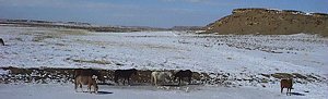 35°50.7N / 107°43.4W -- whitehorse -- seven
lakes trading post -- sr371 (vietnam veterans memorial highway)
-- pass through crownpoint, head to continental divide
at satan pass 7890' about 5 miles south of town
35°50.7N / 107°43.4W -- whitehorse -- seven
lakes trading post -- sr371 (vietnam veterans memorial highway)
-- pass through crownpoint, head to continental divide
at satan pass 7890' about 5 miles south of town 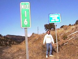 35°34.7N / 108°08.4W -- back to crownpoint
-- drive through town, see the sights -- visit the crownpoint institute
of technology (a competitor to the california institute of technology,
a little-known school for which i work)
35°34.7N / 108°08.4W -- back to crownpoint
-- drive through town, see the sights -- visit the crownpoint institute
of technology (a competitor to the california institute of technology,
a little-known school for which i work) 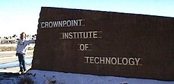 35°40.7N / 108°08.9W -- leave crownpoint,
head west on navajo 9 -- enter navajo indian reservation -- standing
rock prefab town, namesake is kinda interesting two-headed
rock just north of road -- roadside baptist church -- coyote
canyon -- nazhoni -- us666 (the devil's highway)
-- twin lakes -- leave navajo reservation -- see biggest
bunch of junk vehicles ever in indian country, realize moments later
that it's a church and these aren't junk cars, they just look it --
navajo 3 / sr264
35°40.7N / 108°08.9W -- leave crownpoint,
head west on navajo 9 -- enter navajo indian reservation -- standing
rock prefab town, namesake is kinda interesting two-headed
rock just north of road -- roadside baptist church -- coyote
canyon -- nazhoni -- us666 (the devil's highway)
-- twin lakes -- leave navajo reservation -- see biggest
bunch of junk vehicles ever in indian country, realize moments later
that it's a church and these aren't junk cars, they just look it --
navajo 3 / sr264 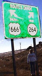 35°38.0N / 108°46.8W -- yah-tah-hey -- navajo
estates: this must be where the upscale navajos live, more
junk cars per lot than i've ever seen before -- biggest shovel i've
ever seen, main body size of 4-5 story building, drag scoop size of
small house? mckinley mine-- black hat -- navajo reservation
35°38.0N / 108°46.8W -- yah-tah-hey -- navajo
estates: this must be where the upscale navajos live, more
junk cars per lot than i've ever seen before -- biggest shovel i've
ever seen, main body size of 4-5 story building, drag scoop size of
small house? mckinley mine-- black hat -- navajo reservation
 35°39.8N / 109°03.0W -- arizona -- sr264 -- apache county
-- window rock capital of the navajo nation -- defiance
plateau summit 7750', nice low forest -- cross canyon
trading post -- turnoff to kinlichee -- ganado
-- hubbell --
35°39.8N / 109°03.0W -- arizona -- sr264 -- apache county
-- window rock capital of the navajo nation -- defiance
plateau summit 7750', nice low forest -- cross canyon
trading post -- turnoff to kinlichee -- ganado
-- hubbell -- 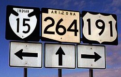 35°45.3N / 109°38.1W -- navajo 15 -- cornfield
off to east across pueblo colorado wash -- sunrise springs
-- navajo county -- greasewood springs -- lower
greasewood -- white cone visible to northwest -- bidahochi--
mount humphreys (arizona's highest peak, in the san francisco mountains)
comes into view on distant western horizon -- dilkon
-- picture shows unnamed volcanic cone left foreground, with elephant
butte in center and in right distance san francisco peaks
35°45.3N / 109°38.1W -- navajo 15 -- cornfield
off to east across pueblo colorado wash -- sunrise springs
-- navajo county -- greasewood springs -- lower
greasewood -- white cone visible to northwest -- bidahochi--
mount humphreys (arizona's highest peak, in the san francisco mountains)
comes into view on distant western horizon -- dilkon
-- picture shows unnamed volcanic cone left foreground, with elephant
butte in center and in right distance san francisco peaks  35°20.1N / 110°33.5W -- coconino county -- bird springs
-- bird springs chapter house -- little colorado river
(flowing) -- leupp
35°20.1N / 110°33.5W -- coconino county -- bird springs
-- bird springs chapter house -- little colorado river
(flowing) -- leupp 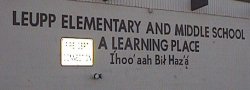 35°17.7N / 111°00.5W -- grand falls baptist church -- leave
navajo reservation -- coconino national forest --
35°17.7N / 111°00.5W -- grand falls baptist church -- leave
navajo reservation -- coconino national forest -- 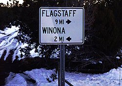 35°12.9N / 111°26.2W -- winona -- townsend-winona
rd -- us89 -- doney park -- flagstaff:
dinner at alpine pizza (7 n leroux st, 520-779-4109), walk down route
66 to have ice cream at The Sweet Life; watch trains roll through town;
decide once again to move here as soon as possible; got fuel 56127,
28.0 gal, 1.159/gal, 89 octane at circle k; mail postcard -- old route
66, turn off to naval observatory, then turn off onto unpaved forest
road and camp for the night 35°11.9N / 111°45.0W 7490'
35°12.9N / 111°26.2W -- winona -- townsend-winona
rd -- us89 -- doney park -- flagstaff:
dinner at alpine pizza (7 n leroux st, 520-779-4109), walk down route
66 to have ice cream at The Sweet Life; watch trains roll through town;
decide once again to move here as soon as possible; got fuel 56127,
28.0 gal, 1.159/gal, 89 octane at circle k; mail postcard -- old route
66, turn off to naval observatory, then turn off onto unpaved forest
road and camp for the night 35°11.9N / 111°45.0W 7490' 35°06.2N
/ 111°43.6W -- oak creek canyon: a little rain, pleasant temperatures
(shirt sleeve) and the mark of a marauding poet
35°06.2N
/ 111°43.6W -- oak creek canyon: a little rain, pleasant temperatures
(shirt sleeve) and the mark of a marauding poet  34°53.1N / 111°44.6W -- sedona crystal-worshipper
central but tremendously beautiful red rock canyons, cliffs and the
quintessential arizona scenery, only one decent mexican restaurant in
town -- yavapai county -- verde river valley -- bridgeport
-- cottonwood
34°53.1N / 111°44.6W -- sedona crystal-worshipper
central but tremendously beautiful red rock canyons, cliffs and the
quintessential arizona scenery, only one decent mexican restaurant in
town -- yavapai county -- verde river valley -- bridgeport
-- cottonwood 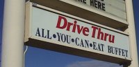 34°43.6N / 112°00.2W what a deal, i just don't exactly know
how it works, since i've never seen a drive-thru buffet, should be in
california -- centerville the center of what? -- clarkdaleis
this the place the monkees were singing about? oh no, that's clarksville
-- prescott national forest -- jerome jerry to his
friends
34°43.6N / 112°00.2W what a deal, i just don't exactly know
how it works, since i've never seen a drive-thru buffet, should be in
california -- centerville the center of what? -- clarkdaleis
this the place the monkees were singing about? oh no, that's clarksville
-- prescott national forest -- jerome jerry to his
friends 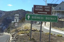 34°44.9N / 112°06.3W -- black hills (mingus mountain) summit
34°42.5N / 112°09.0W elevation 7023' -- yaeger canyon -- chino
valley -- prescott valley
34°44.9N / 112°06.3W -- black hills (mingus mountain) summit
34°42.5N / 112°09.0W elevation 7023' -- yaeger canyon -- chino
valley -- prescott valley  34°27.4N / 112°24.4W elevation 5130' the abandoned right-of-way
of the old prescott branch of the santa fe railway -- granite
dells -- sr89 -- prescott -- willow lake road
-- willow creek road -- iron springs road (yavapai county road 10) --
iron springs -- skull valley
34°27.4N / 112°24.4W elevation 5130' the abandoned right-of-way
of the old prescott branch of the santa fe railway -- granite
dells -- sr89 -- prescott -- willow lake road
-- willow creek road -- iron springs road (yavapai county road 10) --
iron springs -- skull valley 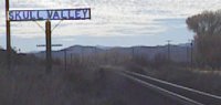 34°30.1N / 112°40.9W --
 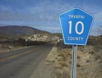 34°25.9N / 112°41.5W -- kirkland -- sr96
/ yavapai 15 -- lower kirkland valley -- yava -- thompsons
valley -- hillside -- mccloud mountains --
santa maria river
34°25.9N / 112°41.5W -- kirkland -- sr96
/ yavapai 15 -- lower kirkland valley -- yava -- thompsons
valley -- hillside -- mccloud mountains --
santa maria river  34°31.5N / 113°07.7W -- sr97 -- bridle creek
 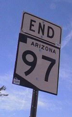 34°25.5N / 113°14.6W -- us93 (the joshua tree parkway of arizona)
-- santa maria river -- sr71 -- merrit pass -- aguila valley -- maricopa
county -- us60
34°25.5N / 113°14.6W -- us93 (the joshua tree parkway of arizona)
-- santa maria river -- sr71 -- merrit pass -- aguila valley -- maricopa
county -- us60 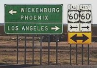 33°56.6N / 113°08.8W -- aguila looking slightly
west of south up toward the top of eagle eye peak you can see the natural?
arch that forms the "eye" of the eagle -- gladden
-- mcmullen valley -- la paz county -- centennial wash drains the entire
region between the harcuvar / granite wash mountains on the northwest
and the harquahala / vulture mountains on the southeast, and even a
bit of the date creek mountains well to the northeast -- wenden
-- salome -- harcuvar -- granite wash
pass: a sweet little pass through which the california and arizona railroad
(nee santa fe parker line) runs; i've camped in the pass a few times,
waited for the never-happening flash floods, never seen a train roll
through, climbed up on the ridges on either side -- hope
33°56.6N / 113°08.8W -- aguila looking slightly
west of south up toward the top of eagle eye peak you can see the natural?
arch that forms the "eye" of the eagle -- gladden
-- mcmullen valley -- la paz county -- centennial wash drains the entire
region between the harcuvar / granite wash mountains on the northwest
and the harquahala / vulture mountains on the southeast, and even a
bit of the date creek mountains well to the northeast -- wenden
-- salome -- harcuvar -- granite wash
pass: a sweet little pass through which the california and arizona railroad
(nee santa fe parker line) runs; i've camped in the pass a few times,
waited for the never-happening flash floods, never seen a train roll
through, climbed up on the ridges on either side -- hope
 33°43.1N / 113°43.1W -- sr72 -- vicksburg
-- mcvay i think that this may be only a siding on
the railroad -- utting same with this -- bouse
unsafe house? guy up on roof making repairs - doesn't look all that
unsafe
33°43.1N / 113°43.1W -- sr72 -- vicksburg
-- mcvay i think that this may be only a siding on
the railroad -- utting same with this -- bouse
unsafe house? guy up on roof making repairs - doesn't look all that
unsafe 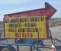 33°55.4N / 113°59.9W -- la posa plain -- sr95 -- parker valley
-- colorado river indian reservation -- parker -- colorado
river
33°55.4N / 113°59.9W -- la posa plain -- sr95 -- parker valley
-- colorado river indian reservation -- parker -- colorado
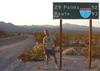
river 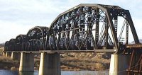 34°09.5N / 114°17.8W -- california@3:24pm pst-- sr62 -- san
bernardino county -- earp -- vidal junction
-- vidal valley -- riverside county -- san bernardino county -- rice
-- rice valley -- colorado river aqueduct -- colorado river aqueduct
-- iron mountain -- riverside county -- granite pass
--
34°09.5N / 114°17.8W -- california@3:24pm pst-- sr62 -- san
bernardino county -- earp -- vidal junction
-- vidal valley -- riverside county -- san bernardino county -- rice
-- rice valley -- colorado river aqueduct -- colorado river aqueduct
-- iron mountain -- riverside county -- granite pass
--  34°02.8N / 115°13.3W -- colorado river aqueduct -- san bernardino
county -- clarks pass -- old dale local sunset occurs
somewhere around here -- self-titled mint mansion: a cinder-block house
painted entirely in a mint-green, right across the street from the twentynine
palms international airport (must be international due to the drug runners)--
twentynine palms watch out for the marines --
joshua tree u2 was here -- yucca valley oh
yucca! -- morongo valley the last dying glow of a beautiful
january 1998 day expires in the deepening sky; there are large cumulus
clouds on the western horizon -- riverside county -- colorado river
aqueduct -- desert hot springs -- interstate 10 --
whitewater -- cabazon i stop to visit
the big lizards here at the wheel inn - the guy who built these two
full-size replicas of a tyrannasaur and a brontosaur died a few years
back at the age of eighty or so; he had planned to build something like
a dozen different ones - he left no one to carry on with the monumental
work
34°02.8N / 115°13.3W -- colorado river aqueduct -- san bernardino
county -- clarks pass -- old dale local sunset occurs
somewhere around here -- self-titled mint mansion: a cinder-block house
painted entirely in a mint-green, right across the street from the twentynine
palms international airport (must be international due to the drug runners)--
twentynine palms watch out for the marines --
joshua tree u2 was here -- yucca valley oh
yucca! -- morongo valley the last dying glow of a beautiful
january 1998 day expires in the deepening sky; there are large cumulus
clouds on the western horizon -- riverside county -- colorado river
aqueduct -- desert hot springs -- interstate 10 --
whitewater -- cabazon i stop to visit
the big lizards here at the wheel inn - the guy who built these two
full-size replicas of a tyrannasaur and a brontosaur died a few years
back at the age of eighty or so; he had planned to build something like
a dozen different ones - he left no one to carry on with the monumental
work 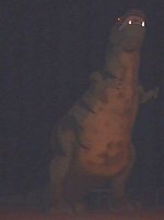 33°55.3N / 116°47.2W -- banning -- beaumont
-- calimesa -- san bernardino county yucaipa
-- redlands there is now some giant cheezy? amusement
park along the north side of the interstate here, called the "pharohs"
or something like that - a giant pyramid, various rides, minature golf,
midget gas-powered race cars, that kind of stuff - i've never heard
of it but now i remember a few billboards over the last thirty miles
or so trumpeting the place -- loma linda from this
point on it's get home, get home, i'm tired of driving -- san
bernardino -- colton -- rialto
-- bloomington -- fontana -- guasti
it's incredible, no matter the time of day or night, the traffic on
i10 sucks from the 15 interchange all the way to the 57/210 interchange
-- ontario -- upland -- montclair
los angeles county -- claremont -- pomona
-- interstate 210 -- san dimas -- glendora
-- azusa -- irwindale san gabriel
river and the world's largest gravel pits? -- duarte
-- monrovia -- arcadia -- pasadena
off at altadena drive -- altadena home at about 8:45pm
33°55.3N / 116°47.2W -- banning -- beaumont
-- calimesa -- san bernardino county yucaipa
-- redlands there is now some giant cheezy? amusement
park along the north side of the interstate here, called the "pharohs"
or something like that - a giant pyramid, various rides, minature golf,
midget gas-powered race cars, that kind of stuff - i've never heard
of it but now i remember a few billboards over the last thirty miles
or so trumpeting the place -- loma linda from this
point on it's get home, get home, i'm tired of driving -- san
bernardino -- colton -- rialto
-- bloomington -- fontana -- guasti
it's incredible, no matter the time of day or night, the traffic on
i10 sucks from the 15 interchange all the way to the 57/210 interchange
-- ontario -- upland -- montclair
los angeles county -- claremont -- pomona
-- interstate 210 -- san dimas -- glendora
-- azusa -- irwindale san gabriel
river and the world's largest gravel pits? -- duarte
-- monrovia -- arcadia -- pasadena
off at altadena drive -- altadena home at about 8:45pm