|
SECTION VI
THE YUMA
SUBDIVISION: THE BRANCH LINES
Introduction
There are six branch lines that serve the
Espee in the Yuma Subdivision: the Riverside and San Bernardino branches
serve the far west end of the Yuma Line, feeding traffic in and out
of the Inland Empire; the Calexico, El Centro and Sandia branches service
the transportation needs of the Imperial Valley with nearly 75 miles
of route; the Yuma Valley Railroad joins the main at Yuma and runs downstream
along the Colorado River for six miles.
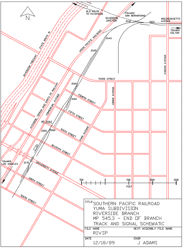
PART 1: THE RIVERSIDE BRANCH
COLTON to RIVERSIDE, MP539.0 - MP546.3
Introduction
The Riverside Branch, like the San Bernardino
Branch in the Section before, is but a shadow of the rail network that
once gridded so much of the Inland Empire.
From the very beginning, this branch provided
freight service from Colton to Riverside, heading nearly due south from Colton,
through the vast citrus groves that blanketed the skirts of the Box Springs
Mountains, east of Riverside. The Pacific Electric Riverside
Line also ran through Colton to Riverside, and shared the right-of-way from Colton to Grand Terrace; from Grand Terrace to Riverside the PE Riverside Line made a beeline to Riverside
Junction and downtown Riverside.
Over the years, the face of the landscape
through which the tracks pass has begun to change; gone are most of
the oranges, sleepy country trails.
Between the Interstate 215 and the Santa Fe Crossings there is
still a substantial amount of the country that gave this branchline
its first life. Along this
stretch there are pastoral scenes that will vanish within the next decade
or so, as light industry and commerce insinuates itself.
Although the branch line is not heavily
used, there seems to be enough traffic originating and ending on the
line that the Espee is willing to spend money on track improvements,
grade crossings and spurs into new industrial parks.
There is even a several-times weekly Riverside Local that sets
out lumber cars at Congress and at Highgrove; oftentimes a pair of Geeps
will be found lurking along the Atlanta Street industry tracks, pushing
or pulling a boxcar either coming or going; the team tracks on the east
side of Commerce Street in Riverside, between Seventh and Eighth, will
reveal late-night carloading in the glow of headlights. According to
the Espee Timetable, the Riverside Branch separates from the Yuma Line
at MP539.0 and ends in Riverside at MP546.4 (by my reckoning, it ends
at MP546.3). Eastbound is from Colton
to Riverside,
though it primarily travels south and west during its 7.3-mile journey.
539.0 Begin RIVERSIDE
Branch (SBD27B2)
West End COLTON
Yard
YUMA LINE Junction
Colton Wye
Right-Of-Way Enters 9th Street
K Street Intersection
Speed Limit: EB 20 MPH
965' AMSL; -0.9% EB
Until
probably the late Forties there was a crossing frog on the Yuma Line
just west of MP539.0. The
tracks leading north from the crossing were the San Bernardino Branch
while the tracks south were the Riverside Branch.
The tracks and crossing were remnants of the old Pacific Electric
Riverside Line that crossed the Espee on its way from San Berdoo to
Riverside.
Today, the Riverside Branch separates from
the main Yuma Line at approximately MP538.8, at the switch next to the
trackside shanty. This lead
track provides access to the south Colton
yard throat and to the top and west legs of the Colton
wye at the north end of 9th
Street.
The tracks proceed down the center of 9th Street from K Street to O Street, a total
of four blocks. 9th Street is extra-wide to accommodate
both the train and the few automobiles that drive up and down the streets
of this sleepy neighborhood.
The long-abandoned footings of a water
tower rest in disarray about 100 feet northeast of the I Street - 9th Street intersection.
539.1 South Switch of Colton Wye
L Street Intersection
M Street Intersection
The east and west legs of the wye meet
in the middle of 9th Street, with a dwarf switchstand marking
the junction a dozen yards north of the intersection of 9th and L. The tracks continue down the center of
9th, protected at L and M Streets by single wig-wags on the west side
of each intersection.
539.2 N Street Intersection
The tracks proceed in the center of 9th Street, crossing
N Street and protected at that intersection by a single wig-wag on the
west side of 9th.
539.3 O Street Intersection
Right-Of-Way Leaves 9th Street
West Switch 1642 Siding
This
ends the shared right-of-way for the Riverside Branch in Colton. The
intersection employs a single wig-wag to warn autos of rail traffic.
Access
to the right-of-way continues on both sides of the tracks, across the
dirt lot ahead. Just
south (railroad east) of the grade crossing lies the west switch of
"Congress siding.
539.6 Congress Street Grade Crossing (SBD27B3)
Old Congress Station
Speed Limit: EB 10 MPH; WB 20 MPH
This was the Congress Station on the PE.
There are the remnants of five
tracks frozen in the asphalt crossing of Congress Street, although the
siding is now all that remains of
what was once a far more busy location.
The majority of the traffic now includes setouts on
the siding track for the industries within a few blocks of here.
The grade crossing at Congress is protected
with an almost comical wig-wag signal, one that must have been struck
by a passing vehicle at one time, twisting and bending the target. It
wobbles as it wigs, dinging its sad little bell each time it wags.
Access continues along both sides of the
track for the next 0.5 miles towards the Santa Ana River
Bridge crossing.
539.7 East Switch 1642 Siding
Signpost EB "5 MPH - BRIDGE"
This is the east switch of the "Congress"
siding. The signpost, between
Congress Street
and the switch, indicates that the maximum speed limit across the bridge
is a blazing 5 MPH. The
bridge is ancient and rickety enough that even that seems like speeding.
539.9 West-facing 1654 Spur
The spur separates to the west of the branch
and leads down into Plexco, a plastics manufacturing plant that fronts
on Jefferson Street. Plexco manufactures a line of fluorescent
orange plastic pipe that finds its way all over Southern
California. Most
of the traffic to this plant is covered hoppers, probably full of the
raw ingredients for their pipe. Maybe tank cars of fluorescent orange,
too.
The dirt access paths on either side of
the tracks continues. The
path on the east side of the tracks will end in a few hundred feet. The path along the west side of the right-of-way
crosses over the 1654 spur and continues south.
540.0 No Milepost Visible (SBD27B4)
West-facing 1650 Spur on 1654 Spur
925' AMSL; +0.6% EB
The 1650 switch, on the 1654 spur, provides
two spur tracks into the facility. Both of these spur tracks go to a junction
switch at the far end of the plant; this switch leads to a
spur
that connects to the Santa
Fe / Union Pacific mainline 1300 feet west.
An old signal mast base and signal box
base are left along the west side of the tracks. The access road to the east of the rails
ends; the path to the west skirts the signal
footings
and continues down into the Santa
Ana River
wash.
Note where there used to be a east-facing
switch that branched off to the east side of the right-of-way; this
switch controlled the east end of a siding that reached all the way
back to Congress Street.
540.1 North End
Santa Ana River
Bridge
A 1400' trestle bridge carries the tracks
across the very tame (deceivingly docile?) Santa Ana River,
reduced to a mere trickle by diversion projects and groundwater pumping
further upstream; certainly drought has some small part in it. The north 1100' of the bridge is completely
of wooden construction; the final 300 feet still employ wooden stringers
but with a steel trestle structure underneath.
Walking across the bridge is a real thrill.
The planking along the east side of the rails is rotten through
and through; in some places the 2x10 planks are actually transparent,
with missing nails and long, sinister cracks. This is a dangerous structure
to walk on unless you're paid to do so. Of course, some people even take strings
of 200-ton LOCOMOTIVES out onto this bridge!
The access road that leads down along the
west side of the right-of-way drops into the Santa Ana River wash and
connects to several paths that lead both up- and downstream. To continue
to follow the railroad from here requires either an amphibious vehicle
or flanged wheels; lacking these the traveler should go back toward
Congress Avenue, go west to La Cadena Drive, then proceed south on La
Cadena across the Santa Ana River Bridge.
Immediately south of the bridge a left turn must be made onto
Terrace Avenue, passing directly under the
Santa Fe
/ Union Pacific tracks and then continuing south to Vivienda Avenue. Go east along Vivienda to the overpass
at MP540.8.
540.2 Speed Limit: EB 5 MPH;
WB 10 MPH
The speed limit is to inhibit those wild
folk who might attempt to cross this bridge at anything greater than
a safe and sane speed; anyway, why be in a hurry?
540.3 Cross Santa Ana
River Main Channel
The wooden pilings under the bridge give
way to steel pilings for the final few hundred feet of bridge.
540.4 South End
Santa Ana River
Bridge
The Santa Ana River
channel lies at the south side of the bridge, where the steel piers
support the rails. In November
1989 a brisk stream, some twenty feet wide and a foot or two deep was
flowing under this bridge.
540.6 Multiple Powerlines Cross
Right-Of-Way (SBD27B5)
Signpost WB "5 MPH - BRIDGE"
Speed Limit: EB 10 MPH; WB 5 MPH
540.7 Leave Colton: Enter Grand Terrace city limits (SBD27A5)
540.8 Vivienda Avenue Overpass
Speed Limit: EB 20 MPH; WB 10 MPH
The right-of-way climbs up from its close
brush with the Santa Ana
River, using a
narrow, man-made notch in the terrace ahead.
Vivienda Avenue crosses over the tracks
on an old concrete bridge. Access
from La Cadena Drive
requires the intrepid driver to pass under the Santa
Fe / Union Pacific main line just south of the Santa Ana River
crossing, then head south along Terrace
Avenue to Vivienda. Turn east on Vivienda, follow this bluff-edge,
winding path around a few kinks in the scarp, and voila!, the railroad
awaits.
541.0 945' AMSL; +0.5% EB
There is no sure access for four-wheeled
vehicles between Vivienda
Avenue and Barton
Road on either side of the tracks; the rails
continue to climb up through the man-made cut onto the mesa upon which
sits the town of Grand Terrace.
541.1 Barton Road Overpass
Leave Grand Terrace: Enter Colton city limits
Access along the tracks is via a dirt path
along the west side up from De
Berry Street.
To get to De Berry
from the Barton Road
overpass, go west on Barton to Terrace
Avenue, then south on Terrace to De Berry Street.
541.2 GRAND TERRACE Station
(SBD27A6)
East-facing 2004 Spur
End Colton
Yard Limits
Enter Absolute Block Register
The 2004 spur services the grocery distribution
facility located at the northeast corner of Terrace Avenue and Barton Road, west of the tracks. The switch is immediately south of
the
Barton Road overpass.
The remains of the Grand Terrace Station
are in a pile to the east of the tracks, about 300 feet south of Barton Road. There
is a concrete foundation wall that still forms the
outline
of what was once the station; piles of wooden pallets, wooden scrap
and bits of masonry litter the immediate area.
Note the switch ties on the main track
a few hundred feet south of the station; these ties supported an east-facing
spur or siding that serviced Grand Terrace station.
Colton Yard limits end. All the way to the end of the branch in
Riverside is Absolute
Block Register
Territory; unless
under special orders, only a single train may be between here and the
end of the branch at one time.
541.3 East-facing 2010 Spur
Perhaps at one time this spur continued
back further toward Grand Terrace Station.
541.4 De Berry Street Grade
Crossing
Old Riverside Line Separation
The long-gone right-of-way for the PE's
Riverside line continues along the same heading, paralleling (more or
less) the freeway and La Cadena Drive all the way to Riverside Junction
in Riverside, about 3-1/2 miles distant. The right-of-way began a gentle descent
through the narrow cut that now guides the powerlines along the same
route.
De Berry Street is named for the De Berry Station
on the PE Riverside Line, and De Berry
was a employee of the Pacific Electric who happens to have been the
father-in-law of a friend of mine.
Access beyond the bridge over the Riverside
Freeway is best made by driving east on DeBerry, then north on La Crosse; make the left
onto Barton Road
and cross the freeway, continuing to Michigan
Avenue.
Turn south on Michigan
to Pico Street. Turn right and return to the railroad tracks
at MP541.9.
541.5 Interstate 215 Underpass
Riverside Canal Access
Road Grade Crossing
A four-span, 270'-long steel through-plate-girder
bridge carries the single-track branch across the Riverside Freeway
(Interstate 215). There
is no room on the bridge for vehicular traffic unless it has flanged
wheels at standard gauge (or it's a bicycle...). The bridge, however, is reasonably walkable.
About 60 feet south of the south end of
the bridge there is a grade crossing for a dirt and gravel access road
that parallels the Riverside
Canal, an open
aqueduct just ahead.
541.6 20' Wooden Bridge over the Riverside Canal
Leave Colton:
Enter Grand Terrace city limits
The railroad passes onto a fill that bridges
a northeastªsouthwest-trending gulley about 100 yards across. The center of the ditch contains the concrete-lined
Riverside Canal, an agricultural water conduit that brings water from
the Santa Ana River upstream near the Interstate 10/215 interchange
down to irrigated fields in the Riverside area.
The canal, about eight feet wide, flows north to south.
Access to the right-of-way south of the
canal to Pico Street
is by foot only.
541.9 West-facing 2015 Spur
(RIV8A1)
Pico Street Grade Crossing
The 2015 spur provides service to a large
lumber yard about 500 yards east, fronting on Main Street. Taylor Street parallels the tracks from
Pico Street south
to Main Street,
immediately to the west of the grade.
There is a crossbuck at this intersection, quoth the Raven, nothing
more.
542.0 East-facing 2022 Spur
Southern California Edison
Highgrove Steam Station
945' AMSL; +0.6% EB
The 542 mile marker is attached to a signal
pole just beyond the 2015 switch. The 2022 spur crosses Taylor Street and
heads down into the Southern California Edison facility just west of
Taylor Street.
542.1 West Switch HIGHGROVE
(2040) Siding
542.2 Main Street Grade Crossing
Leave Grand Terrace: Leave San Bernardino
County
Enter Riverside
County: Enter County
Lands
The grade crossing is protected with crossbucks
and flashing lights.
Access to the tracks between Main and Center is best done in something other than a four-wheeled
vehicle. For most people,
the best method to get from Main Street to Center Street, 0.3 miles
railroad east (compass south), is as follows: Go west (downhill) on
Main Street to Transit Avenue (fronting on the east side of the Santa
Fe main); head south on Transit to Center Street, then east (uphill)
on Center to the tracks.
The prominent peak about two miles due
east is Blue
Mountain.
542.2 West-facing 2045 Spur
The 2045 spur separates to the east from
Highgrove Siding, providing service to the facility immediately north
of Center Street.
542.3 HIGHGROVE Station
Community of Highgrove
Highgrove has been a station on the railroad
since the just after the turn of the century.
542.4 East Switch HIGHGROVE
(2040) Siding (RIV8A2)
Center Street Grade Crossing
The
east switch of Highgrove is about a hundred feet north of the grade
crossing. Center Street, protected at the railroad
crossing with wig-wags and bells, leads west to the Center Street off- and on-ramps at Interstate
215.
A dirt path (California Avenue) the east side of the
tracks allows access between Center and Spring Streets.
542.7 Spring Street Grade Crossing
A lone wig-wag marks the crossing at Spring;
the dirt path (California
Avenue) along the east side of the tracks
is better defined and continues along the rails to MP542.9 at Spring
Brook. Through and beyond there the path gets
quite a bit rougher, but passable.
Go slowly.
542.9 Spring Brook Culvert
The access road (California Avenue) ends at Spring Brook;
a lesser path continues through the bottom of the wash, one that might
get real sticky if wet. Walk
it out if there is any uncertainty.
There are also some occasional deep ruts that require very slow
going with the small wheels of many modern cars.
The 1000-foot-long fill that carries the
rails over the wash consists of old bricks, masonry remains, concrete
foundation debris, perhaps bits of buildings and walls. Very colorful.
Spring Brook drains the north side of the
Box Springs Mountains, the granitic, rocky mass upslope to the east
and south.
543.0 Leave County Lands: Enter
Riverside city limits (RIV8A3)
975' AMSL; -0.3% EB
Slowly but surely all the orchards and
farm lands are vanishing along the Riverside Branch; industrial parks
and parking lots are taking over the once-peaceful, nearly idyllic countryside.
Get your pictures before it's too late.
Paved Prospect Avenue now approaches from the
west and curves to parallel the tracks, but on the west side of the
right-of-way. The north
end of Prospect begins at Center (more or less) and the south end is
at Palmyrita Avenue.
543.2 Palmyrita Avenue Grade Crossing
Block Signal: EB D-5432
The dirt path that followed along the east
side of the railroad ends; Northgate
Street, paved and a bit more official, continues
south, following the tracks immediately to the east of the rails. To the north, the west side of the tracks
is bounded by Prospect
Avenue, paved and robust.
Palmyrita Avenue is protected with the single,
lonely wig-wag at the southwest side of the crossing.
Appropriately enough, there is still the
isolated orange grove or two, along with the eternally-scenic (and ever-present)
palm trees available for good backdrops when the
Riverside
Local rolls by.
The D-5432 signal provides a distant indication
for Riverside-bound traffic approaching the Santa Fe crossing ahead at MP543.9. Based upon some admittedly preliminary
investigations and observations, the 5432 signal does not have the ability
to display a green aspect. The
least restrictive possible is yellow; this is if the Santa Fe crossing ahead is clear.
543.3 ORANGE CENTER
Station
As indicated in the SP Timetable. Otherwise, there is no fame or other notice
to this immediate location.
543.4 Columbia Avenue Grade Crossing
The grade crossing is marked only with
crossbucks and no other indicators.
Columbia,
an east-west byway, arrows downhill through a deep orange grove.
543.5 Right-Of-Way Curves West
Northgate Avenue continues to Marlborough Avenue,
just over one-tenth mile south.
Turn west on Marlborough
to regain the right-of-way. A
finger of the Box Springs mountains stretches far west with its rocky
point nearly touching the Santa
Fe crossing just ahead.
The crossing protection signal at MP543.8
becomes visible right here.
543.7 Right-Of-Way Begins Tangent
(RIV8A4)
543.9 EB Absolute Interlocking
Signal
Marlborough Avenue Grade Crossing
Private Grade Crossing
The signal protects the crossing ahead;
a similar signal 0.2 miles east controls westbound traffic. However, with the amount of traffic that
operates on both the Espee and the Santa
Fe branches, it's probable that interference
is vanishingly rare. If
the crossing is clear of opposing traffic, an approaching SP train will
receive a clear indication (green aspect) from the appropriate facing
signal.
Marlborough Avenue has only crossbucks for
crossing protection; there aren't any local obstructions, though, to
block the view of either trainman or motorist.
The unmarked private crossing provides
a path to get to the water tank, the surrounding territory above the
crossing and to the portals of a tunnel that carry the Gage Canal, another
agricultural aqueduct, under the toe of the ridge.
That little promontory, next to the tank, would be a great place
for a railfan's house. What
a location for train-watching, if there were any trains.
543.9 Santa Fe Perris Branch Crossing
The Perris Branch separates from the Santa Fe main back in Highgrove,
about 2.2 miles north. It
crosses the SP, curves around the bouldered outcrop of the Box Springs
Mountains and passes through the community of Canyon Crest; from there
it
follows
the base of the escarpment and climbs Box Springs Canyon to its eventual
summit in Moreno
Valley, about five miles south and east.
The branch is over 30 miles long, following Interstate 215 to
Perris and then heading east to Hemet.
See if you can catch the rare, rare day
when both trains are near enough to the crossing that the signals display
anything but green.
544.0 Rustin Avenue Grade Crossing
WB Absolute Interlocking Signal
960' AMSL; -0.9% EB
Nothing protects the railroad crossing
at Rustin Avenue;
by December 1989 even the single aged crossbuck had either fallen or
had been knocked down into the ditch alongside the road.
The absolute signal immediately east protects
the Santa Fe
crossing at MP543.9. A like
signal 0.2 miles railroad-west controls eastbound traffic. If the crossing is clear of opposing traffic,
an approaching SP train should receive a clear indication (green aspect)
from the appropriate facing signal.
There is no good trackside path to take
the traveler from Rustin to Iowa
Avenue.
A dirt path used to parallel the south side of the tracks to
Iowa Avenue, but another
industrial complex has since taken its place...
The paved route takes the motorist west
on Marlborough to Iowa, then a left turn south.
544.2 IOWA AVENUE Station (RIV7F4)
Block Signal: WB D-5443
Iowa Avenue Grade Crossing
The tracks cross Iowa Avenue diagonally; a lone wig-wag warns
motorists of the approaching train.
(It cannot do a good job of this; in November 1989 the red lamp
was out, thus making it impossible to see at night.
I'm sure it was quite a surprise for the speeding drivers on
Iowa Avenue when a
gigantic black mass, with airhorn hollering and yellow blinking light
doing just that, rolled out onto the intersection with no warning.)
The signal is a distant indication for
westbound traffic approaching the Santa
Fe crossing at MP543.9. Based upon some admittedly preliminary
investigations and observations, the 5443 signal does not have the ability
to display a green aspect. The
least restrictive possible is yellow; this is if the Santa Fe crossing ahead is clear.
A poor, narrow, rutted path leads between
Iowa Avenue
and Atlanta Avenue
along the south side of the tracks; the trail gets especially narrow
just before Atlanta Avenue.
A hundred feet north of the Iowa Avenue crossing
on the west side of Iowa
is a large building housing the Safeway Egg Department. Is this a research and development facility
for eggs? The location for
the candling crews? I don't
know.
544.4 West Switch 2060 Siding
West-facing 2062 Spur on Siding Track
The 2060 siding allows the Riverside local to get around its cars when servicing the
various industry tracks located on the 2062 spur. There are light industries, warehouses
and small businesses along the west side of Atlanta Avenue between the railroad crossing
at MP544.6 and Marlborough
Avenue.
544.5 East Switch 2060 Siding
Atlanta Avenue Grade Crossing
There is vehicular access between Atlanta Avenue and
Spruce Street through
the parking lot of the facility just north of the tracks; the truly
crazed may try the dirt path along the south side of the tracks. Toward Iowa Avenue, however, it is nearly impassable;
get out of the car and exercise those legs a bit.
544.6 Spruce Street Grade Crossing (RIV7F5)
The rear parking lot for a building on
the southeast corner of Spruce and Chicago
abuts the right-of-way, separated by only a low, concrete-block wall. The crossing protection signals and gates
are all recently new.
544.8 Chicago Avenue Grade Crossing (RIV7E5)
State Route 60 / Interstate 215 Overpass
Speed Limit: EB 10 MPH
Remember: eastbound is towards Riverside, even though at
the end of a short winter afternoon the setting sun will get in your
eyes as you proceed along, following the increasing mileposts.
The tracks forge across Chicago Avenue, protected
by the second and last set of gates on the Riverside Branch. The SR60/I215 bridge provides a permanent
roof for the grade crossing.
Access to the tracks to Massachusetts Avenue
is mainly by foot only, except at Durahart
Street. However, wandering around this neighborhood
at any time might get you a few raised eyebrows; then again, maybe not...
544.9 West-facing 2110 Spur
Durahart Street Grade Crossing
This spur noses compass-west from the branch
track, passing through a few dozen yards of industrial buildings on
its way to a dead end after crossing Durahart Street about a hundred
feet north of the main track crossing.
The spur dies out between buildings about three hundred feet
west of Durahart.
545.0 West-facing 2113 Spur
East-facing 2116 Spur
Massachusetts Avenue Grade Crossing
910' AMSL; -0.6% EB
Spur 2113 turns compass-south and crosses
Massachusetts Avenue,
only to dead-end in the weeds at the south side of Massachusetts. Spur 2116 has a dwarf switchstand and target,
and controls a spur that winds into an industrial facility just north
of Massachusetts Avenue.
The branch line crosses Massachusetts Avenue
and parallels it to Kansas
Avenue. The crossing is indicated by the presence
of crossbucks.
545.2 East-facing 2117 Spur
West-facing 2119 Spur
West-facing 2120 Spur
Spurs 2117 and 2119 service industries
along the south side of Massachusetts;
the 2120 crosses Massachusetts
and curves compass-north into a facility that fronts on Kansas Avenue.
545.3 Kansas Avenue Grade Crossing
East-facing 2131 Spur
The grade crossing at Kansas is protected with crossbucks and flashing
lights. The 2131 spur separates
to the south of the tracks and heads back toward Kansas Avenue.
Just west of the 2131 spur lies the remains
of another spur track; now it is unconnected to the outside world.
Further access along the tracks until MP545.8
is mainly by foot. To get
to MP543.8, take Kansas
Avenue south to Third
Street, turn right (west) and proceed about
three-tenths of a mile to the first railroad crossing. These are the Espee tracks; the next crossings
are all Santa Fe
and Union Pacific.
545.4 RIVERSIDE JUNCTION Station
Paved Pedestrian Crossing
West-facing Spur (no target)
East-facing 2140 Spur
Riverside Junction was the crossing-point
for the Espee tracks at the Santa
Fe / Union Pacific mainline, just a few hundred
feet west. It was at this junction also that the Espee
tracks connected with the PE line from Colton.
The current Riverside branch curves compass-south toward its
eventual terminus on the east side of downtown Riverside. The right-of-way that continues west-northwest
for a short distance are the remains of the old route into downtown
Riverside;
this right-of-way headed about 0.5 miles west to a wye at Market Street, where trains shared the right-of-way
to downtown with cars. The
tracks also followed Market
Street to the north, curving west and eventually
crossing the Espee's
Yuma Line main right around MP535, where
Cedar Avenue
is today. The line north
was called the Riverside-Rialto Line; what little that remains of it
is at Crestmore by the cement
plant
and is operated by the Union Pacific Railroad.
The unmarked west-facing switch is the
top end of a thousand-foot-long industry track that angles due south,
ending about two hundred feet north of Third Street. The 2140 spur winds north and east into
a fenced industrial facility.
545.6 West-facing 2143 Spur
The 2143 spur employs a curved switch to
separate from the branchline.
545.7 West-facing 2145 Spur
Looking at the alignment, it seems that
at one time, long ago, the "diverging" route through the turnout
was not the continuation of the branch.
545.8 Third Street Grade Crossing (RIV7D5)
West-facing 2160 Spur
Ex-East-facing Spur
The Riverside Branch lies about a block
east of the Santa Fe / Union Pacific mainline and jointly, all three
railroads share a nearly-common corridor through the east side of downtown
Riverside along the Riverside Freeway (State Route 91) just about 1000
feet west. The upcoming half-mile or so of railroad
used to be much more busy than it is today; there are still some remnants
of this energetic past nearly buried under the asphalt and dirt of time.
The crossing is protected with crossbucks
and flashing lights.
545.9 Fourth Street Grade Crossing (RIV7D6)
West-facing 2162 Spur on 2160 Spur
West-facing Spur
Fifth Street Grade Crossing
The two switches generate three spur tracks
that attempt to service a few concerns along the east side of the right-of-way.
The 2162 spur ends before Fifth
Street while the latter two continue in the
dust nearly to Sixth Street.
546.0 Sixth Street Grade Crossing
West-facing 5060 Spur
West-facing 2150 Spur
880' AMSL; -0.6% EB
It seems that the 5060 spur is a veritable
fish out of water; its mates are in San Bernardino, on the San Bernardino Branch.
This track crosses Seventh along the east side of the right-of-way,
then ends just before the University Avenue
subway.
The 2150 track ends alongside the loading
ramp south of Seventh; I have watched car loadings and unloadings (at
least I think that's what they were) in the evenings while using truck
headlights for illumination.
There are no signs indicating this crossing.
546.1 Seventh Street Grade Crossing
A single wig-wag provides protection for
this crossing. Seventh Street is an offramp from the Riverside
Freeway, about one thousand feet west.
A loading ramp rests at the west side of
the 2150 spur; it does get a moderate amount of use.
546.2 University Avenue Underpass
Ninth Street Grade Crossing
West-facing 2170 Spur
West-facing Spur
East-facing Spur
A steel through-plate-girder bridge carries
the single-track railroad over the University Avenue subway. Immediately after the bridge is the 2170
switch; it is generally in the reverse position. Two other switches just after the 2170
control two seldom (if ever) used tracks.
This is really the practical end of the
Riverside Branch. Beyond Ninth
Street the tracks enter a fenced and gated
industrial compound; one track exits this compound at Tenth, crosses
that street and dead-ends in yet another fenced yard just south of Tenth.
546.3 Tenth Street Grade Crossing
The tracks are visible through the grade
crossing; anything south of Tenth is impassable due to the storage yard
behind the plant immediately beyond.
546.4 RIVERSIDE Station
End Of Branch
The Tenth Street crossing is about 1700 feet
south of the 546 Milepost; this adds up to less than 546.4.
|