|
Utah
- Arizona Backcountry Adventure
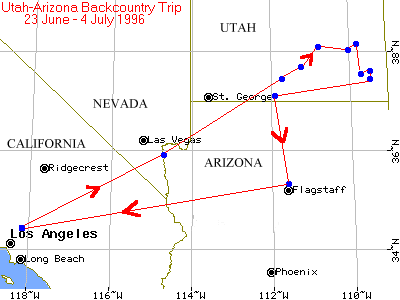
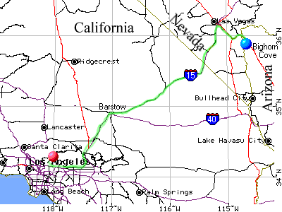
Home, Pasadena, California; Sunday, 23 June 1996, 1300 PDT: Leave home after spending the last 1-1/2 days packing and getting the truck set up for the trip. Start mileage is 36782. Truck is fully fueled. Has amateur radio on board with APRS on HF and VHF to be able to transmit position and simple communications back to home during the trip. At I15 Foothill offramp (Rancho Cucamonga) I visit the Sports Chalet there and purchase something… I just can't remember what… Continue to Barstow on I15, then to Baker and eventually cross into Nevada and stop at Buffalo Bill's to ride the roller coaster and have dinner. Roller coaster definitely worth the $3. Dinner wasn't worth the $7. Is late dusk when I head toward Vegas.
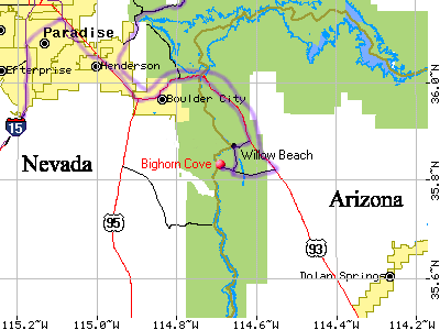
Get off I15 at the Nevada SR146 turnoff to Boulder City south of Vegas. Pick up US 93 in Henderson and head to Hoover Dam. Cross river at dam (9 pm and over 110° - dam hot! (a ha ha HA!)) enter Arizona and continue south a dozen or so miles to the Willow Beach turnoff. Go down to Willow Beach on the Colorado River and find no place to truck camp. Follow dirt road to south that heads up Jumbo Wash to some transmission lines, follow another transmission line access road down to river's edge where transmission lines cross river. It's a place called Bighorn Cove. Park there 1' above waterline. Dead calm, very hot (over 100°) and some mosquitoes… Unload truck enough to sleep inside and bed down for the night, about 2300 PDT.
Bighorn Cove, Colorado River, Arizona; Monday, 24 June 1996, 0700 PDT: Awake with temp only in 90s. Sun already over ridge to east. Surrounded by deeply eroded canyons of lava rock layered with sedimentary rock. Coyote up on ridge is barking incessantly. Seems to be having fun. Ravens are squawking back at him. Load up truck and head back up narrow road about 4 miles to road in Jumbo Wash. Jog right through Jumbo Wash and continue on Mead Liberty Phoenix Powerline Road which in 5.5 miles leads east out to US93. Find a pocketknife at closed gate along side of highway. Head back to Henderson to fuel up and get some forgotten supplies. Stop at Wal-Mart and get sunblock and air pump for inflatable boat, just in case. Leave Henderson and head NE on Nevada SR147 to SR167 to SR169.
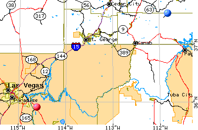
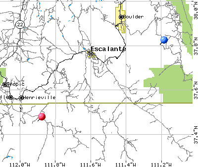
Pass through Overton and eventually regain I15. Cross into Utah after the portal to spectacular Virgin River Gorge where highway engineers built I15 spanning canyon at narrowest point. Hard not to gawk while driving through narrowest part. Make it to St George, stop at Jones Glass and get them to repair leaky seal on right rear quarter panel glass that they installed 12 months before during my last epic vacation (there's a story in itself!). Refuel truck and get some more water and food. Leave St George and attempt to work via prearranged schedule WA4IVF, Gary, in Palm Bay Florida on 20m at 1600 PDT but no luck. Don't hear much at all and call for 15 minutes. Drive through Hurricane and then onto Utah 59 heading SE toward Vermilion Cliffs. Re-enter Arizona (Arizona SR389) and continue along base of Vermilions to Fredonia, Az. Huge brush fires on east side of Kanab Creek down toward north rim of Grand Canyon. Massive smoke clouds trailing off to NE. Go up to Kanab (cross back into Utah) on US89A then east on US89 out of Kanab about 10 miles to turnoff to Skutumpah Terrace via Johnson Canyon. Road is paved for quite a ways - finally reach the dirt Skutumpah road that heads NE to Cannonville. Turn right onto that road and blaze at a good clip along this dusty, clayey road. Very scenic. Stop at crossing over Bull Valley Gorge and check out old pickup truck that went down into gorge and got stuck and all three onboard were killed. Read Kelsey's book on Colorado Plateau for detailed info.
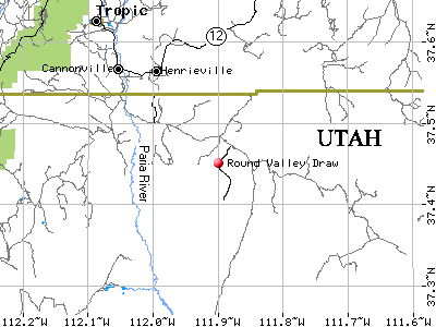
Arrive at the Paria River crossing. Very little water in river (trickle); head toward Kodachrome State Park to camp there for evening. Heard there were hot showers, very deluxe. Get there, beautiful setting, crowded with tourists, too much noise. Not worth hot shower. Leave park and continue east on Cottonwood Canyon road to Rushbeds Road turnoff. Go south, cross shallow Round Valley Draw (immediately above serious narrows) and continue south about ½ mile to turnout and park. Late dusk by now, tired, move some containers out of truck, eat some food, very breezy, pumpkin moon and near full. Smoke from fires in Az getting up this way. Head of Round Valley Draw, Utah; Tuesday, 25 June 1996, 0700 PDT: Smell of smoke comes and goes, pack truck and off to head of Round Valley Draw. At 1000 PDT, park and hike down valley to drop-in to narrows. Very impressive slot in Navajo sandstone. Walk 1 mile or so down slot/narrow canyon, take many pix, gets as deep as maybe 50-70 feet and as narrow as 3' to 4'. Very warm morning, no breeze. Hike out where narrows open into wider canyon, go north up steep defile (250' climb) to top of ridge, then track back ENE getting a little lost (misjudging distances) until I find a drainage to descend and eventually come out about a half-mile downstream from truck. Rim-walk back to entry point into draw and then back to truck. Round trip about 3 hours. Drive over to Butler Valley Arch, climb to top of it, take some photos, then head down Cottonwood Wash Rd to confluence of Paria and Cottonwood. Park truck next to Paria amongst reeds about 1500. Discover deer flies for first time. Wonderful insects. Nasty bites, and plentiful. I am in shorts and t-shirt, carrying water and Kelsey's book on Paria River. Use book to beat flies off. Flies die, but book is becoming battered. Finally hike upstream to little side canyon that gets me away from river (almost no water though) and from flies. Climb up onto mesa above river to the north and quickly find the "hidden cache" that Kelsey describes. In pretty good shape, looks nearly the same as photo in his book. Take some comparison photos and then decide to hike out via north route shown in his book. Step on big boulder and it rolls out from under me, I fall on tailbone and hit hard, bruise butt, tailbone, rip shorts, bleed a little, generally in pain. Continue somewhat more gingerly north attempting to find way off cockscomb. After a few false routes, finally find steep canyon that drops me down through comb to Cottonwood wash, then cross wash and cross country east through more of the comb to pick up Cottonwood Canyon road. Walk south on that about 2 miles to find truck. Last 100' make mad dash to avoid flies. Narrowly avoid them… Smoke is real bad, eyes burn, air stinks, lungs hurt, much worse than bad day in LA.
Decide that there's no reason to tolerate this any longer, drive back up Cottonwood Wash road to Cannonville, then east on Utah 12 to Escalante. At Hole-in-the-Rock (Fifty Mile Cliffs) road, pass out from under veil of smoke into clean air. Drop down spectacular descent into Escalante River at Calf Creek, then climb up north side to awesome road that is built literally on the backbone of a ridge, so narrow that in some places there is a fatal dropoff on either side of the road. Speed limit 25. Arrive town of Boulder before sunset, get onto fabled Burr Trail of old and head away from sunset. First impression is that this is NOT the fabled Burr Trail of old. This is well graded, wide, gentle slope, rough in very few places, definitely not a jeep trail…
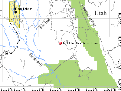
Must have been doing a lot of road work on it. Get to Wolverine Loop Rd turnoff, go south on narrower road that still is good surface of clay. Blaze down to head of Little Death Hollow and attempt to find camp spot in darkness. Find a nice spot a ways NE of corral, complete with fire ring, gnarled juniper, and some firewood and very few junipers for 100 feet. Hard clay surface, no grasses for several hundred feet. Beautiful calm evening, clear sky. Make campfire, wrap something up in aluminum foil, toss into coals. Haven't seen anyone in the last three hours. Hear VOICES to west, eventually see a group of people walking in dark along road. One comes over and I find that they are BLM summer students on a several-week-long wilderness hike. Guy's name is Jason and he informs me that there is a prohibition on fire in Utah. I get out shovel and work to put out fire, while we talk. His group hikes by night and camps by day, started over near Escalante and came up that evening through Little Death Hollow. They must continue to an area near Studhorse Peak where there is a water drop. Very interesting; maybe training for the black helicopter squad??? He leaves, I eat dinner, then prepare for bed. Clear evening, a little breeze from SW. Circle Cliffs, Utah; Wednesday, 26 June 1996, 0505 PDT: Wake up, feel a few raindrops from sparse thin cumuli out of SW. Pack up truck, drive about ½ mile SW to corral at entry to top of Little Death Hollow. Pack up some water and snacks and at 0630 start walk down to the narrows of Little Death. According to Kelsey, best slot in Wingate formation. Starts out as a broad (1 - 1-1/2 miles wide) valley, bounded by high isolated buttes 600-800 feet taller and unclimbable. All the time travelling up in geological strata. First narrows between 0745-0800, 20' wide notch in Wingate. Hear wind gusting above and weird noises like airplanes flying over or sonic booms. Look up and see mostly overcast. By 0815, into serious narrows. 20-30' deep, so narrow that I have to turn shoulders in spots to pass. Awesome. Feel drops of rain! Not good. Deduce that weird noises are thunder and I am trapped in slot canyon that is several miles long. Canyon walls distort sound and make it very hard to recognize. Start trotting and with watch mark potential exits from canyon and upstream time back to them. Come across 12" rattlesnake just as unhappy to be in slot. He is moving in the downstream direction too. I pass him and feel my heels burning. Eventually get out of extreme slot into narrows, discover sky is clearing up again, and sun is coming out. Time to relax. Arrive junction of Little Death and Horse Cyn at 0920, about 7-8 miles from truck. Decide to go up Wolverine via Horse Canyon. Discover deer flies again (or they discover me). It's about a mile before I get beyond the more moist parts of the canyon and out of fly habitat. Only a few bites. Poor Kelsey's book on Colorado Plateau serves as flyswatter and gets beat up some more. Wolverine is less spooky than Little Death, but very impressive in spots. Heels are very sore, I know that I have major blisters. Has gotten cold and windy, overcast and gloomy. Out of nasty parts of canyon, now running low on blood sugar, eat some more dried fruit, continuing to climb long canyon with impressive canyon walls on either side. Lots of petrified wood now. Whole limbs! of wood, several inches in diameter. Nearing top of Wolverine, getting into soft Chinle formation and difficult to travel, can't find a trail much anymore. Know that I need to get around the point to the east to be able to get back to truck, but unsure of the distance. Can't be more than a mile or two or three, but no "as crow flies" route. I blaze up over the Chinle, difficult travel, huge range of colors from yellow to green to grey to brown, oranges too, lots of wood. Starts to rain lightly and Chinle turns to slippery stuff, I slip on a steep slope and find that there are hard, sharp petrified wood slivers embedded in shale. Slice up hands a bit. The Chinle is awesome in its shapelessness. Like heaps of slag, with wild colors and the same mud-cracked surface everywhere. Very steep slopes. Finally make it to the dirt road that leads back to the truck, follow that and pick up a pound of clay mud on boots, laces, socks, and legs. Wash boots of biggest chunks, but like cement and need far more water than I care to waste. So boots come off and go in holding box. Blisters are very bad. Boots are not working. Moleskin did not help. Have crippled myself again!
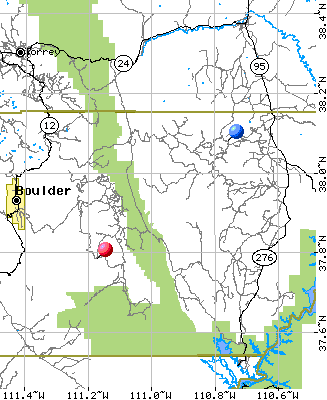
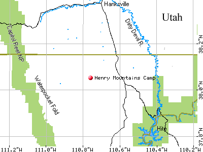
Continue drive east on Wolverine Loop Rd past Moody Cyn turnoff and arrive back to Burr Trail. Head east again on Burr and enter Capitol Reef National Park. Road quality remains freewayish. Then really cool finish: Burr Trail descends through the Waterpocket Fold in an awesome twisty-turny dugway drop of about 600'. Would not want to have trailer in tow. At bottom end of dugway, turn right onto Notom Rd and head south to Bullfrog for fuel. Arrive Bullfrog (37694 miles), fuel up (24.5g@$1.429/) and refill water tanks. Leave Bullfrog and head north on Utah 276 into Henry Mtns (last range discovered in contiguous 48 states). Stop along way, set up and take needed shower. Return to road, find turnoff to Starr Springs (Mt. Hillers), and arrive at Starr Springs campground around 1500. Not too interesting, kinda breezy, and still early in day. Much to see. Continue on road that skirts SE flank of Hillers, eventually go over Hogback and descend very steep slow trail that eventually returns to SR 276. A few miles before SR95, meet dirt road that heads west up the Trachyte Creek then Straight Creek drainage. Work up this road beginning at the 4500' level and eventually make it to nearly 8000' on east flank of Mt Pennell. Turn right and follow road that rides the 8000' level of Pennell to the north and west over to Penellen Pass. Cross the ridge over to the south side of Ellen, then right onto the Ellen perimeter road. About 1 mile before the Crescent Creek road, find a pleasant pulloff to call it a day. Somewhat after sunset. Make dinner, have a beer and settle in for a wet night.
Near Mt. Ellen, Henry Mtns, Utah; Thursday, 27 June 1996, 0600 PDT: Rain intermittent, lightning, some hail during night. Drive north to Lonesome Beaver campground, get up to 9020' in open area with lightning. Not good - too many antennas, too much metal. Road is clay/rock composite, real slick, rain is fairly steady. Crawling along in 4wd, real gentle on the brakes / accelerator. Both heels are in bad shape, left one looks worst. Pass Lonesome Beaver, start down steep Bull Creek Rd that heads to Hanksville. Terribly slick, raining hard. Really chancy, have to crawl and stop a lot to prevent truck from sliding off road. Get down below 7000' and rain lets up, sun starts to peek out from clouds occasionally. Eventually get around Bull Mtn and can see Hanksville to the north. Arrive Hanksville around 1000, cancel reservations for Phantom Ranch four days later. Won't be hiking in on these heels. Get some gauze, tape and Neosporin. Go to BLM office, talk to ranger, find out about Poison Spring Canyon and North Hatch Canyon route into Maze District of Canyonlands.
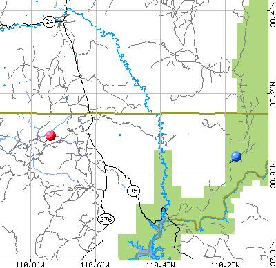
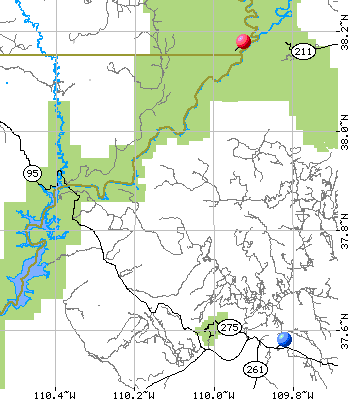
Ranger warns that he hasn't heard about anyone running that route in a while, so unsure about quality of trail. Says the route is extremely difficult, sketchy, high-clearance, and desolate. Sounds cool. Suggests two spare tires, lots of water and fuel. Get fuel for truck (37795, 9.3g@$1.499) and some Diet Coke (Jon runs on Diet Coke). Bought only one roll of film. Will regret this later. Head south on Utah 95 to Poison Springs Canyon Rd turnoff, left turn off highway. Maybe three-tenths mile down Poison Spring Canyon road I find a little turnout to left. Take opportunity to stop, shower, clean and dress feet, and write some notes. Eat a little lunch (dried fruit and tortillas), temp is around 90, elevation around 5000'. Begin descent into unknown. What's this? Road leaves canyon, goes up ridge to south, heads to southeast over rolling highland. Stop for sign indicating that this really is Poison Spring Canyon road, take picture. Continue on. Road drops back into a tributary canyon which works its way northeast back to Poison Spring Canyon. Already about 40 feet deep, maybe 50 feet wide. No water in canyon yet. Looks to be a dry wash, large angular boulders along watercourse, the "road" fairly well graded and cleared. Continue generally southeasterly (though canyon wiggles and waggles) and watch walls climb higher, and more frequent undercuts of walls by what must be large amounts of intermittent flood water. Finally there begin to show little seeps of water on canyon floor, inside walls are maybe 100 feet high with higher outer walls, well set back from road. In spots canyon widens a bit and there are large stands of bullrushes and reeds, often have to navigate through large shallow pools of standing water, many deer flies everywhere. Find pictograph panel on canyon north side near (Wall?) spring (as noted in Kelsey's book). Dash out of truck to avoid too much interaction with dreaded deer flies, am able to snap off a few good shots of the pictographs before deer flies start to smell me out. Good thing I took shower a few miles back! Continue down canyon, absolutely only me and no other signs that humans have been here in the past few days. Make it to the white rim and drop down steep escarpment to new, lower level of the canyon. Now outer canyon is half-mile to mile-wide in spots, inner canyon is maybe couple hundred yards or less sometimes. Temp is steadily increasing as day warms up further and elevation decreases. Get out of truck a few times to snap photos of vistas. Very isolated. Good thing the truck is well-equipped with two-way radios, food, beer and water. Would not want to have to walk out from here. Continue looking southeast and east across chasm that must be the Dirty Devil River and see the vast stratified country of the Orange Cliffs and the Maze district far away. Road continues to be in pretty good shape except for a few sketchy parts. No problem for 4x4 truck, probably ok for 2x4 car even, except for a few dugways that might require a bit of get-up-and-go to get across. Finally work my way down to the Dirty Devil River. Would love to get out and cool off in water, but deer flies are swarming around the truck and the thought of losing blood to the varmints is unappealing. Take a picture of the middle of the stream (river in name only right now - high water was back in May, maybe again in August during monsoon season). Crossing probably no more than 6-10" deep, maybe 30' wide. Temperature is somewhere around 110 deg F out. Reeds and tamarisk grow on both sandy banks, and the river has cut a ruddy canyon nearly 2000 feet deep. Lazy ripples form upstream from me as the stream meets cobbles submerged in the olive-drab water. The path up the dune-like east bank is visible only until it vanishes into the tamarisk - the path barely wide enough for the suburban, the silica-enriched tamarisk screeches against the sides of the truck, imparting yet more hair-fine scratches in the experienced paint. Once up above the river banks, I can see bits and pieces of the way up out of the river bottom - a sinuous, nasty-looking jeep trail that eventually would make its way up onto the Moenkopi bench and thence where? This trail is sandy, very steep and I am completely alone. Between the heat, the emptiness and the very real danger of damaging the truck on the rough path, I am aware of my vulnerability. Out here a failure of some component, and it would be a very long, sobering, simmering hike to civilization. At least there was water, the Dirty Devil, and the two-way amateur radios that could bring help. But in spite of this, the sense of the preciousness of life, the sense of mortality wafted over me. A heady rush, mortality. Up above me to the east were the mile-high cliffs of The Big Ridge, and the North Hatch trail that led me up narrow, heinous switchbacks with vistas of the Dirty Devil and the mouth of Poison Spring Canyon to the west. The spooky thing is always that the Suburban is about 6 feet longer than the vehicle (Jeep) for which this trail was designed, so the shifty switchbacks with the nasty little turning radii continually force me to seesaw my way around the corners with road edges a’ crumblin’. From this most precarious viewpoint I could see a ways up the Dirty Devil but not more than a few miles. Finally the jeep trail leveled out on the Moenkopi, a rich rust-brown clay layer which had attracted the uranium wildcatters who originally cut this jeep trail in the 40’s and 50’s. The Moenkopi is a narrow bench between heaven and hell: the sharp dropoff on the right back into the extreme heat and closeness of the Dirty Devil River canyon, and the steep palisades of the rim country over a thousand feet above me to the left. I could see the necessary route of this trail for the next several miles, following this narrow shelf to the southwest around a distant ruddy point. Eventually the trail came about, now heading east into a vast valley lined with bottomless canyons and towering escarpments. This is North Hatch Canyon. Here and there were massive monuments, whole lonely mesas and nary a sign of humanity, save this path. Looking at the road, the last traveler along this could have been a week or a month ago. The map shows that there is a few paths that lead off this road, probably remnants of mining exploration. I wonder exactly which ridge out in the far distance is the one that I will end up at? It is hot, dry, a little breezy, and the sky has few clouds in it. The dark rust soil is accented with gray-green sage and mesquite, and there are massive fallen pieces of the high palisades that lie to the north. To the south, the Hatch Valley drainage draws closer, the map showing a precipitous, knife-narrow canyon that has notched the plateau to a depth of a thousand feet. To the east, the valley floor steps up occasionally, the road climbing up to the next level, then continuing its eastward journey. It is very dry. I see signs of exploration here and there. Rock cairns abound. Probably built up for surveying for uranium, the cairns sometimes stand six to ten feet tall and interestingly enough look like the evidence for some ancient civilization that worshipped geometry or massive patterns visible only from the sky. Shades of Chariots of the Gods. But indeed it was only guys in jeeps, prowling the Moenkopi in search of the click-clack of decaying uranium measured by their Geiger counters. What adventure they must have had, being out here with no trails and few maps. I feel like a tourist (I am, aren't I?!?). The valley begins to narrow and I am greeted with a stream of clear, rushing water. It is nearly 100, the stream comes from somewhere, flows somewhere else, and it appears that the road has come to an end. Shit. The ranger had said that he wasn’t sure the trail was passable, and I seem to have found that out the hard way. So, I get out of the truck and take a hike overland a half-mile or so up this amazing, lonely stream to see where it goes and if there’s a path hidden somewhere. Indeed, there are no obvious trails on the south bank, and the north bank is a worn scarp of conglomerate, with no possibility of passage. Around the bend, a thousand yards upstream lies a rusted old car from the 40’s? Another few hundred yards it is apparent that the road picks up once again, and it does so from an island in the middle of the stream. Hah! There is the secret: there is no road visible because the only practical path is straight up the middle of the stream. Now to find out if the truck will be able to navigate this relatively shallow but very cobbly and bouldery streambed. I walk back downstream, making a mental note of where the road reappears, and retrace my way to the idling truck. Maybe a kilometer or so, around a sweeping bend in the stream, and the streambed is more or less navigable all the way with little fear of hanging up on a boulder or outcrop. Once back at the truck, I lower myself into the rushing, cool water and plow upstream gently and methodically until I finally arrive where the road reappears. Success! I continue up Hatch Canyon, a canyon now as the walls continue to close in. The water crossings become more common - the water tends to obscure the route a bit so I make a mistake or two and instead follow old trails that climb out of the narrow streambed toward the cliffs to the north. I am sure that there is a way out of here via those cliffs, but today I choose to not attempt jeep trails potentially too heinous for my 6000 lb truck to pass. Another hour passes and I come to a rampart, a neck running WSW-ENE between two narrow, massive orange mesas. The road climbs up and over this wall in a narrow, steep staircase of buff rock, the steps about 6 feet wide and rising perhaps 18-24” per and maybe 3-10 feet treadlength. I have never tried to drive the truck up a staircase before, but there’s always a first time! Except that it’s slow going, the staircase is manageable and soon I am atop the rampart. Only a few hundred feet wide, stretched between two ridges that rise a thousand feet and go for miles to the northeast and southwest, I park and take in the view and look downvalley to where I began hours before. This has been quite a journey, so far, and I have no idea where I am going next. I look to the east, and see that to continue on this path will lure me into a remote valley, surrounded by mesas and ridges on all sides but with an obvious watercourse gently scoring the valley bottom along the southeast edge. Approximately due east, there is another notch over which I believe that this trail must go. So, down into this mysterious valley I descend, down another sandstome staircase, down amongst the pinyon. The soil is very orange here. Indeed, ahead lie the Orange Cliffs, or at least the west edge of them and they represent the western boundary of the Orange Cliffs unit of the Lake Powell National Recreational Area, which has laid claim to this remote bit of Utah desert. I continue east by southeast, descending finally into the parched, Mars-red stream bottom and navigating slowly up the narrowing watercourse towards who knows what or where. I’m not sure how I’ll get out of this except to return from where I came, but that doesn’t sound so interesting. It’s now maybe 4pm, the sun is still high in the west, and I’m climbing the far saddle that I had seen earlier an hour earlier. The sky to the east is dark and heavy with the generally evanescent rain that the plateau sees this early in the season. The slope in front of me is a melange of pinon, almost graceful from a distance but up close gnarled and rough. This is Sunset Pass, and beyond it lies the mysterious Orange Cliffs unit of the Lake Powell National Recreational Area, the Maze District of Canyonlands National Park, and most especially the awesome Dollhouse. Up and over Sunset Pass I go. The road is pretty darned good now, no more streambeds, just roostertail city as I speed along at 40-50mph toward my destiny. I am descending the eastern slope of Sunset Pass, which lies at the north end of "The Block" section of the Orange Cliffs. To the north lies Teapot Rock, and the high mesas. To the east is the Dollhouse. Just behind me is Gunsight Butte. To the southwest, after nearly 40 miles or unknown but most likely dusty, rough road is Utah 95 and (just a bit farther) Hite, Utah. To the northeast is the Maze Overlook. Geez - so many cool places that I’ve never been. I finally make the junction of the North Hatch Trail and the Flint Trail. I am on an expansive plain, tilting gently to the southeast, and looking deceptively safe and smooth. The Flint Trail is a freeway; this is the way normal people get into this part of the great beyond. To the north, the Flint appears to work its way up toward the high mesa, to the south it can only follow the sweep of the Orange Cliffs since there doesn’t appear to be any other way to get around that barrier. The signpost here indicates the distance to Hans Flat Range Station, to Utah 95 at Hite, and to Utah 95 at the west end of the Poison Spring Canyon (the route that I came in on). Looking at the map and not wanting to tackle the unknown too much on this hot, humid afternoon I opt for the south, driving about a mile or so before I come to another road junction. I get out and inspect. This is the Dollhouse road. The Dollhouse. A tortuous trail leads out over the sinous backbone of a broken sedimentary ridge, with incredible views, terrible dropoffs, and astounding hoodoos and statues, and canyons. All to protect the unprepared explorer from the hideous wonder of the dollhouse, a vast amphitheater of giant alien totems, each with its own personality. It’s 23 miles to the end of the road from here, and the road appears pretty good right here. I begin to think that maybe the reports of the road’s difficulty are overstated, like the Burr Trail earlier. However, it’s late in the day and I’d rather find a spot to camp and sort out the day’s journey. So, I continue south along the Flint Trail until I’m in the lee of the Orange Cliffs.
|